|
|
|
|
|
|
|
|
|
 |
|
|
|
|
|
|
|
|
|
|||||
|
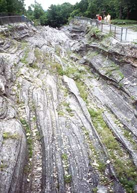
Glacial legacies The bioregion of Northeast Ohio was shaped by mountains of ice, and the impacts on land, water and wetland plant communities linger today By John Katko North America's last episode of glaciation began about 2 million years ago when the earth's climate, for reasons not wholly understood (but having to do with its carbon-dioxide-oxygen cycle), cooled significantly. A vast amount of water was deposited by the planet's water cycle over the polar regions. As the pile of snow accumulated to a thickness of about two miles at the center (somewhere over Greenland), the material packed itself into ice. While we think of ice as a solid material, given enough time and pressure it acts in a plastic manner-that is, it flows like a very thick, sluggish liquid. Ice bulldozer This thick pile of ice thus flowed outward from its center and eventually reached latitudes as far south as Ohio. The outer edges of this mass of ice were thousands of feet thick, and melted away during the summers (with highs of perhaps 70 to 80º F. near the glacial borders). As it spread outward, rather like a very thick pancake batter will do as more and more is ladled onto the center, it bulldozed the ground, scraping and plucking up bedrock boulders and stones which became incorporated into the bottom of the ice and acted as the 'dozer blade. There was also a great deal of dirt and dust deposited upon the ice by wind, and this material may have eventually supported forests atop the glaciers, which in turn enriched the soil material with organic matter. If the glacier was spreading out faster than it was melting at the edges, it was advancing. If it melted faster than it spread, it was in retreat. If the two processes happened at the same rate, the edge of the glacier would appear to stand still, but the leading edge would still be melting away and depositing anything from clay-sized particles to truck-sized boulders at its foot. If the glacier retreated from such a situation, it would leave behind an end moraine. Retreating glaciers also left behind a more general bed of deposits called ground moraine. This material may have simply settled down onto the ground as the ice melted, or it may have been carried off or out of the glacier by meltwater. These deposits tended to be sorted by the rate of water flow, and they formed ridges and bars called kames and eskers, which are often rich sources of sand and gravel. The advancing glaciers often excavated new valleys and basins. Lake Erie, for example, is deeper in its eastern and central basins where the glaciers plowed through relatively soft shales and sandstones, and shallower in the western basin where the dolostones and limestones were more resistant. Other drainage valleys were filled in. Ohio's largest drainage system, the northwesterly-flowing Teays in central and southern Ohio, was largely obliterated by the glaciers. Three advances There were three main glacial advances in Ohio. The first, called the Kansan (there is some evidence for an earlier Nebraskan advance, but it is of minor importance in Ohio glacial geology), began about 700,000 years ago, and its deposits are almost entirely buried by more recent advances. The Illinoian advance then began about 125,000 years ago, and again is mostly obliterated on the surface by material from the last advance, called the Wisconsinan. The Wisconsinan ice sheet covered the state twice-the first time about 70,000 years ago and the last time beginning about 25,000 years ago. It is this last advance that left most of the surface deposits that we see in Ohio today. The advancing glaciers tended to flow around the Allegheny Plateau, which covers southeastern Ohio in a broad arc from just south of Ashtabula County through Morrow County and down to Adams County on the Ohio River. However, they did flow up on to the plateau in northeastern and central Ohio. Thus, there is a glaciated section of the Allegheny Plateau as well as an unglaciated section. Ohio's unglaciated Allegheny Plateau, because of its hilly nature, has the fewest and most isolated wetlands in the state. Where the bedrock is sandstone, such as in the Hocking Hills area, most wetlands are within floodplains of the streams that dissect the hills. Other small wetlands, seldom reaching more than an acre in size, may occur where springs and seeps emerge from the rocky hillsides. Plants from the north Another interesting thing about the wetlands of the unglaciated plateau is that their plant communities (as well as those of the drier areas in this section of the state) are more closely derived from the ancient plant communities of the Smoky Mountains. Often referred to as Carolinian species (e.g., sweetgum, southern blackhaw, sweet buckeye, river birch, pignut hickory, Carolina willow, summer grape, redbud, wild hydrangea, blackjack and post oaks, pumpkin ash, persimmon), these plants were obliterated in northern Ohio by the glaciers. When the ice melted they were replaced by more northerly (boreal) and westerly species (e.g., speckled alder, leatherleaf, larch, mountain holly, nannyberry, gray birch, dune willow, shining willow, pin oak, swamp white oak, red-berried elderberry, cranberry, spiraeas, fox grape, basswood, arrowwood). These plants were brought in by the glaciation, both by seeds within the ice and by forests that actually sometimes established themselves atop the glacier. Once the glaciers disappeared many of these newcomers were able to maintain a foothold within the landscapes and ecologies that were the legacies of the glaciers. An excellent example of such a situation is a habitat rare in Ohio called an Alvar, which is best seen on Kelleys Island where flat, porous limestone surfaces scraped bare by the glacial ice are very slow to allow soils to reform and woody vegetation to re-establish itself. Thus our plant communities of today are influenced not only by soil and bedrock chemistry, porosity, and composition, by light exposures, availability of water, and terrain features, but by the legacy of the glacial actions as well. Bogs and fens The glaciated Allegheny Plateau in Ohio is quite rolling and is rich in end moraines and kames. Mostly underlain by shales, which are very slow to allow water to seep through, this area is rich in fens and hydrologically isolated bogs and marshes. Bogs are formed when blocks of ice become separated from receding glaciers and leave a depression when, after being surrounded by the material from glacial outwash, they melt. Fens form when water seeps out of material that contains calcareous material like limestone, which turns the water alkaline. The sorted material in the kames of this area often contains much calcareous material carried down from Canada by the glaciers, and so we have the fens of the Portage Lakes area, Herrick Fen, etc. There are also many marshes and small lakes in this area that are surrounded by marshy areas. This section of the state also has some of the largest inland wetland areas, Killbuck Marsh and the Funk Bottoms, both of which are formed along stream valleys and kames. The broad area of southwestern Ohio (and the extreme northwest corner) is called the Till Plains section. Most of this area is underlain by dolomite, which is similar to limestone but is composed of magnesium carbonate instead of calcium carbonate. Once fairly swampy (with much pin oak) and marshy with both dry and wet prairie, this rather level region has been mostly drained for agriculture and grazing. Most of its wetlands are now gone. After the retreat The last advance of the Wisconsinan glacier began to end about 14,000 years ago, and the glacier was gone from the Great Lakes region by about 9,500 years ago. It was during this time that Lake Erie was formed. As the glacier retreated, the water that ponded at its base at first covered an area that extended well to the southwest of the Lake's present shores, as far as Paulding and Van Wert Counties on the Indiana border. At first, Lake Erie drained to the southwest into the Mississippi drainage, but as the glacier retreated and uncovered other avenues of drainage (including, finally, the Niagara escarpment), the outlines and flow direction of the forming lake changed. This change was not always gradual; the forming lake went through a series of temporarily stable stages, which have been named Lakes Maumee, Whittlesey, Arkona, Warren, Grassmere, and Lundy, all of which left behind sandy beach ridges in places. By far the most wetland-rich region in Ohio is within the area once covered by ancient Lake Erie (Maumee etc.). This region of the state, called the Lake Plains section, is quite flat, has poorly drained silty or clayey soils at its surface (formed when under water), and is underlain by poorly-drained shales and by dolostones. These wetlands tend to be extensive, especially the Great Black Swamp, which once covered about 900,000 acres in northwest Ohio. Today, after decades of drainage for agriculture, practically nothing of this huge wetland is left. Inland the Black Swamp was a mosaic of marshlands within mostly swamp forests. Along the coastline were vast emergent marshlands that were a vital part of the Lake Erie ecosystem. There were also vast marshlands within and along Sandusky and Muddy Creek Bays. Besides providing fabulous habitat and feeding grounds for amphibians, reptiles, birds, and mammals, this was prime breeding and nursery habitat for many of Lake Erie's fish species. The disappearance of these wetlands has had a profound negative impact on the fisheries of the lake. Coastal marshes The reason these coastal marshes were (and still are) most extensive off of the southern coast of western Lake Erie has much to do with the lay of the land along the lake. When the glaciers dug out the lake bed, they did so most shallowly across the harder dolostones exposed in the western part of Ohio. Thus there is very little gradient at the shoreline there. An important feature of these coastal marshes were the sand bars that lay close to shore. These reefs were composed of the larger-sized sand particles that the waves eroded out of the bedrock or till material that lay along the coastline and dragged out into the lake. Because waves rarely hit the shore head-on but usually approach at an angle, this eroded material is moved by wave action to the east or west, depending on the angle of the shoreline and the prevailing direction of winds, especially during storms. This is called long-shore or littoral drift. Most of the material dragged out into the lake is composed of clay-sized particles and is washed far away, but the heavier sandy material falls out to the bottom fairly quickly, forming the sand bars that are so important in shielding the coastal marshes of the western basin from the force of waves off the lake by absorbing their energy and causing them to break before they reach the fragile vegetation (cattails, water lilies, sedges, reeds, etc.). It is important for the lake to have access to sand-sized particles in order to form these sandy reefs. When most of the shoreline of the central and western basins was diked off or riprapped with big limestone blocks, this source of sandy drift material was denied. Now, big storms have broached the near-shore reefs, and the coastal marshlands of such places as Metzger Marsh and Sandusky Bay are exposed to the full fury of the lake. These areas have either become big mud flats (e.g. Sandusky Bay and much of Metzger Marsh) or must be protected from lake energy by dikes (e.g. Ottawa National Wildlife Refuge and the planned rehabilitation of Metzger Marsh). In contrast, along the more easterly shoreline of Lake Erie in Lorain, Cuyahoga, Lake, and Ashtabula counties, there is usually a shale bluff or cliff from five to 80 feet tall along the shore. This precludes the development of extensive coastal marshes except where rivers emptying into the lake have cut through the coastal ramparts and have supported the development of estuarine-type marshlands within broad, flat stream valleys. Most of these estuaries have been eradicated by urban and industrial development. The best surviving examples are Old Woman Creek National Estuarine Preserve and Mentor Marsh. Also largely gone are inland wetlands within the Lake Plains section in Erie and Lorain Counties. These formerly extensive marshes and wet forests lay between the sandy beach ridges left by early Lake Erie stages. Most have been turned into residential and commercial developments. Lake Plain swamp forests are now one of the most threatened habitats in Northeast Ohio. John Katko is president of Friends of Wetlands, an advocacy group based in Lorain County. For more information, write to PO Box 2016, Elyria, OH 44036, or call 440-324-7522.
EcoCity Cleveland |
|
||||
Banyak pemain mencari slot yang memberikan peluang menang lebih besar. Dengan Slot Deposit 5k, pemain bisa menikmati permainan dengan tingkat kemenangan yang lebih tinggi dibandingkan biasanya. Ini menjadi pilihan utama bagi mereka yang ingin memaksimalkan kemenangan dengan modal kecil.
Banyak pemain berpengalaman memanfaatkan data harian untuk memilih mesin dengan slot rtp tertinggi hari ini. Ini menjadi salah satu cara untuk meningkatkan peluang menang secara signifikan. Dengan adanya RTP live, pemain bisa mendapatkan informasi real-time tentang slot mana yang lebih menguntungkan. Memilih mesin dengan slot gacor juga menjadi trik yang banyak digunakan untuk mendekati kemenangan besar.
Simbol Scatter Hitam dalam permainan slot berfungsi sebagai pemicu fitur bonus yang menguntungkan. Ketika muncul di layar, Scatter ini memberikan kesempatan untuk mendapatkan free spins atau hadiah spesial lainnya. Dengan posisi yang strategis, Mahjong Slot meningkatkan peluang pemain untuk memperoleh hadiah yang lebih besar dalam setiap permainan.
Skin eksklusif terbaru langsung jadi incaran para player sultan, detail lengkapnya ada di bd-innovations.com. Server game tadi sempat maintenance cukup lama. Untungnya sekarang sudah normal lagi dan bisa push rank.
Skin eksklusif yang lagi rame dipakai player top ternyata bisa didapat dengan cara yang cukup simpel, langkah lengkapnya ada di pedetogel. Banyak pemain baru sering bingung cara cepat naik level di awal permainan. Padahal ada beberapa tips sederhana yang bisa mempercepat progres.
Skin eksklusif terbaru ini bikin karakter kamu makin standout di arena, langsung intip tampilannya via TOGEL158. Main bareng teman bikin game lebih seru. Apalagi kalau pakai voice chat sambil bercanda.
Skin eksklusif terbaru akhirnya muncul dengan desain yang beda dari sebelumnya dan bikin karakter makin standout langsung cek situs toto. Tips farming yang efisien sekarang banyak dibagi pemain veteran di forum. Lumayan ngebantu pemain baru biar nggak salah langkah.
Skin eksklusif edisi terbatas ini cuma muncul sekali dan detail lengkapnya ada pada Situs Toto. Update patch biasanya membawa balancing karakter atau senjata. Hal ini penting supaya permainan tetap adil bagi semua pemain.
Skin eksklusif edisi terbatas ini cuma muncul sebentar dan efek animasinya beda dari biasanya, cara dapetinnya bisa kamu simak lewat toto slot. Meta terbaru bikin beberapa karakter jadi overpowered. Saatnya atur ulang strategi biar tetap kompetitif.
Banyak pemain slot online yang mencari permainan dengan RTP tinggi, dan Slot Gacor menjadi salah satu yang paling dicari. Game ini dikenal memiliki pola permainan yang mudah dipahami dan sering memberikan kemenangan besar. Dengan tampilan modern serta berbagai fitur bonus yang menarik, pengalaman bermain semakin seru. Tidak heran jika game ini selalu menjadi pilihan utama bagi para penggemar slot yang ingin mendapatkan cuan besar.
Dalam dunia hiburan digital yang terus berkembang, banyak orang memilih metode transaksi modern dan cepat, sehingga Slot Qris menjadi solusi praktis untuk menikmati permainan tanpa repot proses pembayaran.
Dalam dunia permainan online, banyak strategi yang bisa diterapkan, namun salah satu metode yang sering direkomendasikan oleh pemain berpengalaman adalah mencoba slot bet kecil untuk menguji pola permainan sebelum meningkatkan taruhan.
Saat ini, banyak pemain mencari platform terpercaya untuk bermain, dan Situs Toto hadir sebagai solusi terbaik. Dengan tampilan yang user-friendly, pemain dapat dengan mudah menelusuri berbagai fitur yang tersedia. Kemudahan dalam melakukan deposit dan withdraw juga menjadi salah satu faktor utama yang membuat banyak orang memilih platform ini.
Sebagai salah satu situs yang sangat populer, Situs Togel menawarkan berbagai pasaran dari negara-negara terkemuka. Di sini, pemain dapat menemukan pilihan pasaran seperti Hongkong, Singapore, hingga Macau, yang semuanya memiliki hasil pengundian yang akurat. Dengan tampilan yang sederhana namun efisien, Situs Togel memberikan kemudahan bagi pemain untuk bertaruh dengan nyaman.
Banyak pemain togel yang mengandalkan Data Macau sebagai referensi utama dalam menyusun strategi taruhan mereka. Data ini mencakup hasil keluaran sebelumnya yang bisa dianalisis untuk menemukan pola angka tertentu. Dengan menggunakan metode statistik, banyak pemain yang berhasil meningkatkan peluang kemenangan mereka. Selain itu, beberapa situs togel juga menawarkan layanan analisis data yang lebih mendalam. Oleh karena itu, memiliki akses ke data ini sangat penting bagi setiap pemain togel.
Ketika membahas permainan angka, tidak sedikit pemain yang menjadikan Toto macau sebagai pilihan utama karena menawarkan sensasi menegangkan sekaligus kesempatan mendapatkan hadiah besar.
Kinerja stabil dan dukungan teknologi terkini membuat slot server Thailand menjadi pilihan favorit, terutama bagi pemain yang mengutamakan kenyamanan, kecepatan, dan keadilan dalam bermain.
Setiap pemain memiliki preferensi sendiri dalam memilih platform permainan, namun di antara banyaknya nama besar, kehadiran Slot88 di dunia hiburan digital menjadi simbol konsistensi dalam memberikan layanan cepat, tampilan menarik, serta reputasi sebagai tempat bermain yang adil dan menguntungkan.
Proses registrasi menjadi lebih sederhana karena sistem permainan kini memanfaatkan Togel Online sebagai elemen pendukung utama yang mempermudah langkah awal pemain.
Skin eksklusif edisi terbatas ini cuma muncul sekali dan tampilannya bikin karakter makin sangar, intip dulu toto togel. Kalau koneksi sering drop coba main di jam sepi. Ping lebih stabil dan matchmaking biasanya lebih cepat.
Skin eksklusif yang baru rilis ini bukan cuma soal tampilan, tapi juga efek animasi yang bisa kamu lihat pada toto togel. Update patch kecil sering dianggap sepele padahal dampaknya besar. Perubahan kecil bisa bikin meta bergeser.
Skin eksklusif edisi terbatas ini cuma muncul sebentar dan efek animasinya bikin auto pamer di lobby, intip toto togel. Update kecil kadang kelihatan sepele tapi efeknya ke gameplay besar banget. Salah build dikit bisa langsung kalah di ranked.
Skin eksklusif edisi terbatas ini bikin tampilan karakter makin beda dari yang lain, detail lengkapnya bisa kamu lihat pada Bandar Togel. Banyak pemain lama balik main karena ada reward comeback menarik. Progress jadi nggak terasa ketinggalan jauh.
Skin eksklusif yang cuma muncul sekali ini lagi jadi incaran banyak player dan detailnya ada pada toto slot. Patch balance kadang bikin karakter favorit jadi makin kuat. Tapi ada juga yang harus rela ganti strategi.
Skin limited lagi comeback dan tampilannya bikin ngiler, cek detailnya pada Situs Togel. Kalau ping kamu sering naik turun, coba ganti server yang paling dekat. Main jadi lebih smooth dan nggak gampang emosi.
Skin eksklusif limited lagi balik lagi dan tampilannya makin sangar, info lengkapnya bisa kamu intip lewat situs toto. Tips buat push rank: jangan egois dan fokus objektif. Komunikasi tim itu kunci biar menang terus.
Skin limited edisi spesial udah nongol dan animasinya gokil parah, list skinnya cek Toto Togel. Kalau kamu sering kalah, coba cek ulang build dan item yang kamu pakai. Kadang masalahnya cuma salah urutan beli.
Banyak forum berbagi pengalaman menyarankan pendekatan realistis, karena meskipun Togel menawarkan sensasi menebak angka, pemahaman probabilitas dan batasan pribadi tetap menjadi fondasi penting dalam setiap keputusan.
Skin eksklusif edisi terbatas ini lagi jadi incaran para pemain karena tampilannya beda dari biasanya, lihat detailnya sabatoto. Komunitas game makin rame dengan diskusi strategi terbaru. Banyak tips berguna yang bisa kamu tiru dari sana.
Skin eksklusif terbaru akhirnya rilis juga dan tampilannya bikin karakter makin keren, lihat tampilannya di togel279. Tips leveling cepat lagi banyak dicari pemain baru. Strategi ini bisa bantu kamu naik level tanpa ribet.
Skin eksklusif terbaru ini lagi jadi incaran banyak player karena tampilannya keren banget, lihat detailnya pada Togel158. Tips leveling cepat selalu jadi incaran pemain baru. Dengan strategi yang tepat, progress bisa lebih ngebut.
Togel178 menyediakan berbagai jenis permainan yang bisa dipilih oleh para pemain, dari yang paling sederhana hingga yang lebih kompleks, semuanya bisa ditemukan dengan mudah di situs ini.
Di Togel178, kamu akan merasa nyaman bermain karena platform ini tidak hanya menawarkan berbagai jenis permainan tetapi juga menjamin transaksi yang aman dan terpercaya.
Perkembangan dunia permainan online semakin pesat dan banyak pemain mulai beralih ke Ratukura karena layanan yang tersedia mampu memberikan kenyamanan akses serta transaksi praktis tanpa proses rumit.