|
|
|
|
|
|
|
|
|
 |
|
|
|
|
|
|
|
|
|
|||||
|
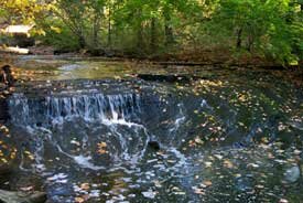
Bedrock and glaciers By Joe Hannibal Our surface and subsurface rocks have been exploited for various products including water, sandstone, natural gas and salt. Upper layers of this rock are exposed in places, providing much valued scenic outcrops. The greatest treasures found in these rocks, however, are their fossils. These fossils, together with analysis of the rock layers themselves, provide us with an increasingly detailed picture of ancient seas and landscapes. This rock sequence preserves a record of vastly different environments from those of today. Foundation rock The foundation of our bioregion consists of a thick sequence of sedimentary rock laid down between 540 and 300 million years ago. These sandstones, shales and limestones lie upon "basement" rocks of even greater antiquity. The basement rocksgranites, gneisses, and related rocksrecord the eroded and metamorphosed roots of a mountainous and hilly terrain. A continental suture and a rift basin are preserved in very ancient (Precambrian to Cambrian) deep rocks just to the west of us. Most of the overlying sedimentary rocks represent vast incursions of seas onto the continent and accompanying nearshore deposits. There are 6,000 to 7,000 feet of sedimentary rockshales, sandstones, and related rocksbelow us. These rocks occur in layers that are usually flat and sheetlike. The most fascinating of these rock layers are the Upper Devonian (360 million-year-old) shales and sandstones that are exposed along streams and roadcuts across the northern part of the bioregion. These rocks contain remains of ancient fish, crustaceans, and plants, some of which resemble modern forms, others of which are quite different. These organisms lived on or offshore of a shallow, continental sea that laid on the flank of a great land mass called the Old Red Sandstone Continent. Today's shales are compacted sea-bottom muds that formed offshore of this land mass; our sandstones formed as nearshore sand bodies. Younger rocks Since the rocks of our region are distributed in a more-or-less classic layer cake fashion, younger rock layers are found above the older layers. At higher elevations somewhat younger rocks can be found. These date to the Mississippian and Pennsylvanian Periods. These rocks represent fluctuating sea levels. The Sharon Conglomerate, a pebbly sandstone, which tops our local sequence of bedrock, is a river deposit. The rivers were a type known as "braided," very wide and very shallow (one of those "foot deep and a mile wide" rivers), replete with intertwining streamlets. The pebblesalmost all made of quartz from Canadaare known as lucky stones. On the north line of the outcrop of Sharon Conglomerate there are disjunct outliers of conglomerate. These outliers form hills, such as the hills along Interstate 480 in Twinsburg. The most famous outliers are the "knobs" of Lake and Geauga counties. Rivers and lakes During and after the time of the dinosaurs (the Mesozoic Era), our area was a highland. Since highland areas tend not to accumulate sediment that becomes rock, there are no rocks in our area dating to the time of the dinosaurs or thereafter. Erosionnot depositionof sediments, was the dominant force during these later times. Long after the demise of the dinosaurs, large river systems ran through our area. Most were connected to a river that ran along what is now the long axis of Lake Erie. Then, between 2 million years ago and about 10,000 years ago, came the ice. It is this glacial ice that determined the final shaping of the landscape as we know it today. The glaciers carved out and enlarged previous river valleys, and covered most everything with dirt, sand and a sprinkling of exotic, Canadian boulders. Then they melted back to form a series of lakes roughly where the Great Lakes are today. Several former "Lake Eries," having different configurations, formed in the waning stages of the Ice Age. Some of these lakes covered what is now the northern part of our bioregion. This area is now known as the Lake Plain. The Lake Plain is a relatively narrow band running roughly east-west. The rest of our bioregion is an upland area known as the Allegheny Plateau. The Allegheny Plateau is a broad plateau leading into western Pennsylvania and, eventually, into the Appalachian Mountains themselves (though the hills of the plateau are hardly the "foothills of the Appalachians" as some have dubbed them). The escarpment The steep area that connects the Lake Plain and the Allegheny Plateau is called the Portage Escarpment. It is best developed to the east of Cleveland. (It's why the Heights are the heights.) You can see the escarpment while driving east along Interstate 90, or you can drive up it at places like the base of Cedar Road. But, better yet, look down the escarpment onto the Lake Plain from the overlook of Garfield Memorial in Lake View Cemetery, along the Cleveland-Cleveland Heights border. Some of our best rock outcrops are on the escarpment. Because of the lush greenery of our bioregion, the rocks are chiefly exposed along roadcuts and streambeds. Increasingly, roadcuts are being covered over, and streambeds are being culverted (a process that might be termed sewerification). So the best rock exposures are along the larger streams (too big to transmogrify into a sewer) and along any stream that traverses the escarpment. For it is along the escarpment that the stream gradient is high, water moves faster, and erosion occurs more quickly. Valleys and ridges During the Ice Age, prehistoric river valleys were cut into the bedrock here and thereonly to be filled by the next glacial advance or retreat. Present rivers sometimes run along the same or nearly the same pathsbut not always the directionas these prehistoric rivers. Although the prehistoric valleys are filled in, they are still of great importance. They are sources of well water for some communities. And tall buildings built over the great prehistoric pre-Cuyahoga river valley in downtown Cleveland must make accommodations for the 200 feet of relatively soft glacial sediment that they are perched upon. Prehistoric beach ridges are among the most prominent features of the Lake Plain. These sandy ridges formed along the shores of previous high levels of the predecessors to Lake Erie between 35,000 and 12,000 years ago. Several prominent east-west roads now run along these ridges. Sometimes the road names reflect this. Center Ridge Road, for example, runs on Middle Ridge. These beach ridges drop off on both sides, however, so they may not have been beaches in the strict sense, but most were surely nearshore sand bodies, often developed on top of terraces. The ridges, being sand bodies, are well drained, making good places for trails, roads and farm houses. Glacial remains Up on the plateau, the major features are glacial end moraines (broad, hummocky ridges composed of sand and other debris laid down at former ice margins) and some glacial lakes. Geauga Lake, Chippewa Lake, and Twin Lakes in Kent are among these. These bodies of water were probably formed when a huge chunk of ice was surrounded by sediment as the glaciers retreated. When the ice melted, a holenow a lakewas left behind. Many more, smaller, ice age lakes have filled in with peat. Our soils are derived from rocks and glacial materials. Sandy soils are often developed over prehistoric beaches and sandbars. Lake bottom clays and soils developed over shales are clayey. So drainageand farminghas a lot to do with underlying rock and glacial material (of course, all gardeners know this). As our cities and suburbs have expanded, development of farmland and steep-sided areas has caused problems. Housing has been built on soils not especially suitable for development. Soils underlain by shales are often wet and clayey and have high water tables. Constant change Geological processes are still transforming our area. Most noticeable is the erosion along the Lake Erie shore. While the shores are generally receding along most of the lake, the greatest amount of erosion is along shoreline sections composed of glacial sediment. Shores lined with bedrock erode much more slowly. Beaches afford some protection. Artificial structures can also provide protection in the short run, but they may accelerate erosion in neighboring areas. Joe Hannibal is curator of invertebrate paleontology at the Cleveland Museum of Natural History.
EcoCity Cleveland |
|
||||
Banyak pemain mencari slot yang memberikan peluang menang lebih besar. Dengan Slot Deposit 5k, pemain bisa menikmati permainan dengan tingkat kemenangan yang lebih tinggi dibandingkan biasanya. Ini menjadi pilihan utama bagi mereka yang ingin memaksimalkan kemenangan dengan modal kecil.
Banyak pemain berpengalaman memanfaatkan data harian untuk memilih mesin dengan slot rtp tertinggi hari ini. Ini menjadi salah satu cara untuk meningkatkan peluang menang secara signifikan. Dengan adanya RTP live, pemain bisa mendapatkan informasi real-time tentang slot mana yang lebih menguntungkan. Memilih mesin dengan slot gacor juga menjadi trik yang banyak digunakan untuk mendekati kemenangan besar.
Simbol Scatter Hitam dalam permainan slot berfungsi sebagai pemicu fitur bonus yang menguntungkan. Ketika muncul di layar, Scatter ini memberikan kesempatan untuk mendapatkan free spins atau hadiah spesial lainnya. Dengan posisi yang strategis, Mahjong Slot meningkatkan peluang pemain untuk memperoleh hadiah yang lebih besar dalam setiap permainan.
Skin eksklusif terbaru langsung jadi incaran para player sultan, detail lengkapnya ada di bd-innovations.com. Server game tadi sempat maintenance cukup lama. Untungnya sekarang sudah normal lagi dan bisa push rank.
Skin eksklusif yang lagi rame dipakai player top ternyata bisa didapat dengan cara yang cukup simpel, langkah lengkapnya ada di pedetogel. Banyak pemain baru sering bingung cara cepat naik level di awal permainan. Padahal ada beberapa tips sederhana yang bisa mempercepat progres.
Skin eksklusif terbaru ini bikin karakter kamu makin standout di arena, langsung intip tampilannya via TOGEL158. Main bareng teman bikin game lebih seru. Apalagi kalau pakai voice chat sambil bercanda.
Skin eksklusif terbaru akhirnya muncul dengan desain yang beda dari sebelumnya dan bikin karakter makin standout langsung cek situs toto. Tips farming yang efisien sekarang banyak dibagi pemain veteran di forum. Lumayan ngebantu pemain baru biar nggak salah langkah.
Skin eksklusif edisi terbatas ini cuma muncul sekali dan detail lengkapnya ada pada Situs Toto. Update patch biasanya membawa balancing karakter atau senjata. Hal ini penting supaya permainan tetap adil bagi semua pemain.
Skin eksklusif edisi terbatas ini cuma muncul sebentar dan efek animasinya beda dari biasanya, cara dapetinnya bisa kamu simak lewat toto slot. Meta terbaru bikin beberapa karakter jadi overpowered. Saatnya atur ulang strategi biar tetap kompetitif.
Banyak pemain slot online yang mencari permainan dengan RTP tinggi, dan Slot Gacor menjadi salah satu yang paling dicari. Game ini dikenal memiliki pola permainan yang mudah dipahami dan sering memberikan kemenangan besar. Dengan tampilan modern serta berbagai fitur bonus yang menarik, pengalaman bermain semakin seru. Tidak heran jika game ini selalu menjadi pilihan utama bagi para penggemar slot yang ingin mendapatkan cuan besar.
Dalam dunia hiburan digital yang terus berkembang, banyak orang memilih metode transaksi modern dan cepat, sehingga Slot Qris menjadi solusi praktis untuk menikmati permainan tanpa repot proses pembayaran.
Dalam dunia permainan online, banyak strategi yang bisa diterapkan, namun salah satu metode yang sering direkomendasikan oleh pemain berpengalaman adalah mencoba slot bet kecil untuk menguji pola permainan sebelum meningkatkan taruhan.
Saat ini, banyak pemain mencari platform terpercaya untuk bermain, dan Situs Toto hadir sebagai solusi terbaik. Dengan tampilan yang user-friendly, pemain dapat dengan mudah menelusuri berbagai fitur yang tersedia. Kemudahan dalam melakukan deposit dan withdraw juga menjadi salah satu faktor utama yang membuat banyak orang memilih platform ini.
Sebagai salah satu situs yang sangat populer, Situs Togel menawarkan berbagai pasaran dari negara-negara terkemuka. Di sini, pemain dapat menemukan pilihan pasaran seperti Hongkong, Singapore, hingga Macau, yang semuanya memiliki hasil pengundian yang akurat. Dengan tampilan yang sederhana namun efisien, Situs Togel memberikan kemudahan bagi pemain untuk bertaruh dengan nyaman.
Banyak pemain togel yang mengandalkan Data Macau sebagai referensi utama dalam menyusun strategi taruhan mereka. Data ini mencakup hasil keluaran sebelumnya yang bisa dianalisis untuk menemukan pola angka tertentu. Dengan menggunakan metode statistik, banyak pemain yang berhasil meningkatkan peluang kemenangan mereka. Selain itu, beberapa situs togel juga menawarkan layanan analisis data yang lebih mendalam. Oleh karena itu, memiliki akses ke data ini sangat penting bagi setiap pemain togel.
Ketika membahas permainan angka, tidak sedikit pemain yang menjadikan Toto macau sebagai pilihan utama karena menawarkan sensasi menegangkan sekaligus kesempatan mendapatkan hadiah besar.
Kinerja stabil dan dukungan teknologi terkini membuat slot server Thailand menjadi pilihan favorit, terutama bagi pemain yang mengutamakan kenyamanan, kecepatan, dan keadilan dalam bermain.
Setiap pemain memiliki preferensi sendiri dalam memilih platform permainan, namun di antara banyaknya nama besar, kehadiran Slot88 di dunia hiburan digital menjadi simbol konsistensi dalam memberikan layanan cepat, tampilan menarik, serta reputasi sebagai tempat bermain yang adil dan menguntungkan.
Proses registrasi menjadi lebih sederhana karena sistem permainan kini memanfaatkan Togel Online sebagai elemen pendukung utama yang mempermudah langkah awal pemain.
Skin eksklusif edisi terbatas ini cuma muncul sekali dan tampilannya bikin karakter makin sangar, intip dulu toto togel. Kalau koneksi sering drop coba main di jam sepi. Ping lebih stabil dan matchmaking biasanya lebih cepat.
Skin eksklusif yang baru rilis ini bukan cuma soal tampilan, tapi juga efek animasi yang bisa kamu lihat pada toto togel. Update patch kecil sering dianggap sepele padahal dampaknya besar. Perubahan kecil bisa bikin meta bergeser.
Skin eksklusif edisi terbatas ini cuma muncul sebentar dan efek animasinya bikin auto pamer di lobby, intip toto togel. Update kecil kadang kelihatan sepele tapi efeknya ke gameplay besar banget. Salah build dikit bisa langsung kalah di ranked.
Skin eksklusif edisi terbatas ini bikin tampilan karakter makin beda dari yang lain, detail lengkapnya bisa kamu lihat pada Bandar Togel. Banyak pemain lama balik main karena ada reward comeback menarik. Progress jadi nggak terasa ketinggalan jauh.
Skin eksklusif yang cuma muncul sekali ini lagi jadi incaran banyak player dan detailnya ada pada toto slot. Patch balance kadang bikin karakter favorit jadi makin kuat. Tapi ada juga yang harus rela ganti strategi.
Skin limited lagi comeback dan tampilannya bikin ngiler, cek detailnya pada Situs Togel. Kalau ping kamu sering naik turun, coba ganti server yang paling dekat. Main jadi lebih smooth dan nggak gampang emosi.
Skin eksklusif limited lagi balik lagi dan tampilannya makin sangar, info lengkapnya bisa kamu intip lewat situs toto. Tips buat push rank: jangan egois dan fokus objektif. Komunikasi tim itu kunci biar menang terus.
Skin limited edisi spesial udah nongol dan animasinya gokil parah, list skinnya cek Toto Togel. Kalau kamu sering kalah, coba cek ulang build dan item yang kamu pakai. Kadang masalahnya cuma salah urutan beli.
Banyak forum berbagi pengalaman menyarankan pendekatan realistis, karena meskipun Togel menawarkan sensasi menebak angka, pemahaman probabilitas dan batasan pribadi tetap menjadi fondasi penting dalam setiap keputusan.
Skin eksklusif edisi terbatas ini lagi jadi incaran para pemain karena tampilannya beda dari biasanya, lihat detailnya sabatoto. Komunitas game makin rame dengan diskusi strategi terbaru. Banyak tips berguna yang bisa kamu tiru dari sana.
Skin eksklusif terbaru akhirnya rilis juga dan tampilannya bikin karakter makin keren, lihat tampilannya di togel279. Tips leveling cepat lagi banyak dicari pemain baru. Strategi ini bisa bantu kamu naik level tanpa ribet.
Skin eksklusif terbaru ini lagi jadi incaran banyak player karena tampilannya keren banget, lihat detailnya pada Togel158. Tips leveling cepat selalu jadi incaran pemain baru. Dengan strategi yang tepat, progress bisa lebih ngebut.
Togel178 menyediakan berbagai jenis permainan yang bisa dipilih oleh para pemain, dari yang paling sederhana hingga yang lebih kompleks, semuanya bisa ditemukan dengan mudah di situs ini.
Di Togel178, kamu akan merasa nyaman bermain karena platform ini tidak hanya menawarkan berbagai jenis permainan tetapi juga menjamin transaksi yang aman dan terpercaya.
Perkembangan dunia permainan online semakin pesat dan banyak pemain mulai beralih ke Ratukura karena layanan yang tersedia mampu memberikan kenyamanan akses serta transaksi praktis tanpa proses rumit.