|
|
|
|
|
|
|
|
|
|
|
|
|
|
|
|
|
|
|||||
|
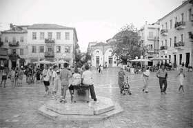
Reclaiming the streets
The art and practice of "traffic calming" is growing around the world, along with literature on how to do it. For the following articles, we borrowed heavily from Streets and Sidewalks, People and Cars by the California-based Local Government Commission, Take Back Your Streets by the New England-based Conservation Law Foundation, and Traffic Calming by the Australia-based Citizens Advocating Responsible Transportation. By Ryan McKenzie Most of us would like to live our lives, work and play along streets that have low traffic volume, slow speeds and minimal noise. And yet the streets, neighborhoods and urban centers we've built over the last 50 years have often created just the opposite conditions wide, fast, noisy, dirty streets. Indeed, the American landscape has been given over to the automobile. While this mass "automobility" has made life more convenient in some ways, it's degraded our quality of life in many others. We have spent billions of dollars to make our public spaces hostile and often dangerous for anyone not inside an automobile. And we have allowed the car to displace walking, bicycling, and transit. It's not surprising that we have done this. In America, mobility is equated with power and freedom. Even our language values travelers over those who are simply enjoying the public realm. We have words for "motorist," "cyclist," and "pedestrian," but how should we refer to the elderly couple sitting on a park bench, the student waiting at a bus stop, or the kids playing ball in a neighborhood front yard? Bystanders? Non-motorists? Without a term that distinguishes them from people in motion, our fellow citizens-at-rest in the public realm have routinely been undervalued and ignored. The rise of traffic calming But after years of neglect, street design is re-emerging as an important issue in neighborhood and city planning. Civic leaders are rediscovering streets as public spaces that should serve the needs of all citizensincluding pedestrians, bicyclists and those who are simply out enjoying the public right of way. In many parts of the country, this movement to retrofit streets has resulted in efforts to implement "traffic calming." Consisting of mostly physical changes to roadways that reduce speeding and traffic volumes, traffic calming helps create livable communities where it is easy to travel by bicycle, car, transit or on foot, and to transfer from one mode of transportation to another. In general, traffic calming serves two purposes:
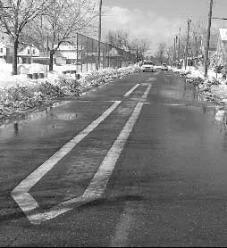
Traffic calming acknowledges that accommodating motor vehicles is important, but it is only one of many functions that should be served by our public rights of way. In Taking Back Your Streets, the Conservation Law Foundation reminds us, "A street is the landscape outside someone's living room or bedroom window, or at the edge of a park. It's what people see and hear as they eat in a restaurant or leave a church or synagogue." Thus, more than commonly recognized, the design of our streets shapes the livability of our communities. Organized traffic calming began as a grassroots movement in Europe in the late 1960s. Angry residents of the Dutch city of Delft fought cut-through traffic by turning their streets into woonerven, or "living yards" where cars are allowed as "guests" at walking speeds, and non-motorists always have the right of way. This was followed in the late 1970s by the development of European slow streets (designed for speed limits of 20 mph) in commercial and city center areas; the application of traffic calming principles to intercity highways through small Danish and German towns in the 1980s; and the areawide treatment of urban main roads in Germany and France. By the early 1990s traffic calming principles had spread to parts of Florida and the Pacific Northwest, and interest continues to grow around the U.S. Getting out of the car With friendlier streets, more Americans might be motivated to get out of their cars. After all, more than one-quarter of the trips Americans take are less than one mile long a walkable distance. And almost one-half of trips are less than three miles long appropriate for bicycling. Shifting our transportation habits to walking and biking would bring tremendous benefits. Advocates for nonmotorized travel note that pedestrians and cyclists do not consume imported oil, cause smog or acid rain, pollute waterways, add to the risk of global climate change, create noise, or create demand to pave more of our landscape for parking. In addition, walking and biking are good ways to get the additional exercise that many of us want and need. Today, more than half of American adults are overweight or obese an epidemic in the eyes of the American Medical Association. In an editorial in its journal, the AMA noted that car trips have replaced trips that used to be made on foot or by bicycle and that helping people get back to walking or bicycling should be a first target in combating the obesity epidemic. But it also noted: "Reliance on physical activity as an alternative to car use is less likely to occur in many cities and towns unless they are designed or retrofitted to permit walking or bicycling." National and local health organizations have begun promoting more walkable communities as a fundamental way to improve public health. The U.S. Centers for Disease Control is working to promote "Active Community Environments," places where people can easily walk and bicycle. The California Department of Health Services states, "Our vision is a state where doctors prescribe walking and bicycling to their patients, employers subsidize bike facilities and community trails, and transit services accommodate cyclists by making intermodal travel safe and seamless." Dangerous designs Yet our transportation system continues to make it difficult for us to walk or bike for even some of our daily needs. Highway departments take it for granted that high levels of service must be provided to more and more motorists, with little consideration of the effect this might have on those not driving pedestrians, bicyclists, neighbors, children and others. In pursuit of these goals, lanes are widened, curves are straightened, and traffic signals are re-timed, all to accommodate the journey by car. Even the most fundamental pedestrian safety tool, the walk signal, usually allows cars to make right and left-hand turns across the crosswalk during the walk sequence. What's worse, many of those signals are timed for use by young adults in good health, and don't give elderly or disabled people enough time to cross in safety. These policies have taken a very real human toll on low-speed travelers. According to a recent national study, walking is 36 times more dangerous than driving. (Mean Streets 2000 by the Surface Transportation Policy Project). In 1999, a whopping 481 pedestrians and 208 bicycles were involved in motor vehicle accidents in the City of Cleveland alone. This could be an emerging social and environmental justice issue, as researchers are documenting a disproportionate number of pedestrian injuries and deaths among Latinos and African-Americans. Street Design 101 Although one might think that posting additional speed limit or stop signs should address traffic problems, experience has shown that these are not effective traffic calming measures. The physical design of streets themselves influences a driver's behavior more than any other factor. Under standard guidelines, road design is determined by municipal, county and state engineers, primarily on the basis of (1) its proposed "design speed," (2) its "functional classification," and (3) the traffic volumes to be accommodated in a specific future year. Design speed: The "design speed" is the highest speed at which a motorist can drive safely under ideal road and weather conditions, regardless of the posted speed limit. When engineers modify a road in our region, they generally work with a design speed at least ten miles per hour higher than its posted speed limit. This signals to motorists that speeding is safe and encouraged, which intensifies the hazards faced by cyclists and pedestrians. According to the Conservation Law Foundation, "Regardless of posted speed limits, motorists will drive faster when given the 'safety cushion' of a wider road and greater sight distances. Higher design-speed roads have an insidious psychological effect on most motorists, prompting them to increase their speed unwittingly." Functional classification: Every street and road in Ohio has been put in a category according to the function it is supposed to play in moving traffic through the roadway system. These functional classifications are determined by state and regional planning agencies, using Federal Highway Administration guidelines. Roads are assigned to the following classifications:
The classification of a road is critical. The higher a road's functional classification, the higher its design speed is likely to be and the more motorists will respond by using it heavily. Traffic volumes and level of service: The design of most road projects assumes that a community must accept forecasted growth in traffic at prevailing speeds, even if those speeds are above the posted speed limit. Typically, a project is designed to accommodate the traffic predicted to occur on a road 20 years in the future. It is not designed merely to accommodate traffic at that point in time, but to provide a very high "level of service" (LOS) to motorists. The result of all these standard design factors is a road that is wider and faster that it needs to be today. The design process is biased against the needs of everyone not driving a car. What can local communities do? While it is true that federal and state engineering standards govern the design of roadways, local elected officials and citizens can request design modifications where a one-size-fits-all approach doesn't fit local circumstances. The standards actually allow for far more flexibility than many road designers realize. Communities can start with traffic-calming techniques that begin to change the physical design of streets moderating the flow of traffic and making streets less hazardous. A sampling of these techniques is provided in the Tools section of this site. Beyond these techniques, local decision makers influence the character and livability of their streetscapes in other ways. Local land use laws determine the placement, use and design of buildings that shape the surrounding street environment. Neighborhood design features trees, medians, sidewalks, on-street parking also change the feel of streets, and therefore influence motorist behavior. At the municipal planning level, the development of walking-sized districts with a variety of housing, shopping, work and recreational opportunities can reduce the need for car travel, decrease traffic volumes, and reduce the cost-per-citizen to provide first-class transit, walking, and bicycling infrastructure. Known by names such as "New Urbanism" and "Transit-Oriented Development," these traditional neighborhood planning principles are regaining esteem around the country. Their popularity is also encouraging older cities like Cleveland to reconsider their attitudes toward "outdated" street networks, and to find new value in the potential walkability and livability of once-forgotten urban neighborhoods. And there's one more important thing for everyone to do be more active and assertive about claiming the right to be in the streets. Walk. Bike. Organize block parties. Use the street like a neighborhood living room. If we don't get out in the streets, our public spaces will continue to be dominated by the automobile.
EcoCity Cleveland |
Citizens Advocating Responsible Transportation (CART)
There is no question that conditions for bicycling and walking need to be improved in every community in the United States; it is no longer acceptable that 6,000 bicyclists and pedestrians are killed in traffic ever year, that people with disabilities cannot travel without encountering barriers, and that two desirable and efficient modes of travel have been made difficult and uncomfortable. Federal Highway Administration, Accommodating Bicycle and Pedestrian Travel: A Recommended Approach More than one quarter of all trips today are one mile or less, yet trips taken on foot have dropped by 42 percent in the last 20 years. Mean Streets 2000, Surface Transportation
|
||||
Banyak pemain mencari slot yang memberikan peluang menang lebih besar. Dengan Slot Deposit 5k, pemain bisa menikmati permainan dengan tingkat kemenangan yang lebih tinggi dibandingkan biasanya. Ini menjadi pilihan utama bagi mereka yang ingin memaksimalkan kemenangan dengan modal kecil.
Banyak pemain berpengalaman memanfaatkan data harian untuk memilih mesin dengan slot rtp tertinggi hari ini. Ini menjadi salah satu cara untuk meningkatkan peluang menang secara signifikan. Dengan adanya RTP live, pemain bisa mendapatkan informasi real-time tentang slot mana yang lebih menguntungkan. Memilih mesin dengan slot gacor juga menjadi trik yang banyak digunakan untuk mendekati kemenangan besar.
Simbol Scatter Hitam dalam permainan slot berfungsi sebagai pemicu fitur bonus yang menguntungkan. Ketika muncul di layar, Scatter ini memberikan kesempatan untuk mendapatkan free spins atau hadiah spesial lainnya. Dengan posisi yang strategis, Mahjong Slot meningkatkan peluang pemain untuk memperoleh hadiah yang lebih besar dalam setiap permainan.
Skin eksklusif terbaru langsung jadi incaran para player sultan, detail lengkapnya ada di bd-innovations.com. Server game tadi sempat maintenance cukup lama. Untungnya sekarang sudah normal lagi dan bisa push rank.
Skin eksklusif yang lagi rame dipakai player top ternyata bisa didapat dengan cara yang cukup simpel, langkah lengkapnya ada di pedetogel. Banyak pemain baru sering bingung cara cepat naik level di awal permainan. Padahal ada beberapa tips sederhana yang bisa mempercepat progres.
Skin eksklusif terbaru ini bikin karakter kamu makin standout di arena, langsung intip tampilannya via TOGEL158. Main bareng teman bikin game lebih seru. Apalagi kalau pakai voice chat sambil bercanda.
Skin eksklusif terbaru akhirnya muncul dengan desain yang beda dari sebelumnya dan bikin karakter makin standout langsung cek situs toto. Tips farming yang efisien sekarang banyak dibagi pemain veteran di forum. Lumayan ngebantu pemain baru biar nggak salah langkah.
Skin eksklusif edisi terbatas ini cuma muncul sekali dan detail lengkapnya ada pada Situs Toto. Update patch biasanya membawa balancing karakter atau senjata. Hal ini penting supaya permainan tetap adil bagi semua pemain.
Skin eksklusif edisi terbatas ini cuma muncul sebentar dan efek animasinya beda dari biasanya, cara dapetinnya bisa kamu simak lewat toto slot. Meta terbaru bikin beberapa karakter jadi overpowered. Saatnya atur ulang strategi biar tetap kompetitif.
Banyak pemain slot online yang mencari permainan dengan RTP tinggi, dan Slot Gacor menjadi salah satu yang paling dicari. Game ini dikenal memiliki pola permainan yang mudah dipahami dan sering memberikan kemenangan besar. Dengan tampilan modern serta berbagai fitur bonus yang menarik, pengalaman bermain semakin seru. Tidak heran jika game ini selalu menjadi pilihan utama bagi para penggemar slot yang ingin mendapatkan cuan besar.
Dalam dunia hiburan digital yang terus berkembang, banyak orang memilih metode transaksi modern dan cepat, sehingga Slot Qris menjadi solusi praktis untuk menikmati permainan tanpa repot proses pembayaran.
Dalam dunia permainan online, banyak strategi yang bisa diterapkan, namun salah satu metode yang sering direkomendasikan oleh pemain berpengalaman adalah mencoba slot bet kecil untuk menguji pola permainan sebelum meningkatkan taruhan.
Saat ini, banyak pemain mencari platform terpercaya untuk bermain, dan Situs Toto hadir sebagai solusi terbaik. Dengan tampilan yang user-friendly, pemain dapat dengan mudah menelusuri berbagai fitur yang tersedia. Kemudahan dalam melakukan deposit dan withdraw juga menjadi salah satu faktor utama yang membuat banyak orang memilih platform ini.
Sebagai salah satu situs yang sangat populer, Situs Togel menawarkan berbagai pasaran dari negara-negara terkemuka. Di sini, pemain dapat menemukan pilihan pasaran seperti Hongkong, Singapore, hingga Macau, yang semuanya memiliki hasil pengundian yang akurat. Dengan tampilan yang sederhana namun efisien, Situs Togel memberikan kemudahan bagi pemain untuk bertaruh dengan nyaman.
Banyak pemain togel yang mengandalkan Data Macau sebagai referensi utama dalam menyusun strategi taruhan mereka. Data ini mencakup hasil keluaran sebelumnya yang bisa dianalisis untuk menemukan pola angka tertentu. Dengan menggunakan metode statistik, banyak pemain yang berhasil meningkatkan peluang kemenangan mereka. Selain itu, beberapa situs togel juga menawarkan layanan analisis data yang lebih mendalam. Oleh karena itu, memiliki akses ke data ini sangat penting bagi setiap pemain togel.
Ketika membahas permainan angka, tidak sedikit pemain yang menjadikan Toto macau sebagai pilihan utama karena menawarkan sensasi menegangkan sekaligus kesempatan mendapatkan hadiah besar.
Kinerja stabil dan dukungan teknologi terkini membuat slot server Thailand menjadi pilihan favorit, terutama bagi pemain yang mengutamakan kenyamanan, kecepatan, dan keadilan dalam bermain.
Setiap pemain memiliki preferensi sendiri dalam memilih platform permainan, namun di antara banyaknya nama besar, kehadiran Slot88 di dunia hiburan digital menjadi simbol konsistensi dalam memberikan layanan cepat, tampilan menarik, serta reputasi sebagai tempat bermain yang adil dan menguntungkan.
Proses registrasi menjadi lebih sederhana karena sistem permainan kini memanfaatkan Togel Online sebagai elemen pendukung utama yang mempermudah langkah awal pemain.
Skin eksklusif edisi terbatas ini cuma muncul sekali dan tampilannya bikin karakter makin sangar, intip dulu toto togel. Kalau koneksi sering drop coba main di jam sepi. Ping lebih stabil dan matchmaking biasanya lebih cepat.
Skin eksklusif yang baru rilis ini bukan cuma soal tampilan, tapi juga efek animasi yang bisa kamu lihat pada toto togel. Update patch kecil sering dianggap sepele padahal dampaknya besar. Perubahan kecil bisa bikin meta bergeser.
Skin eksklusif edisi terbatas ini cuma muncul sebentar dan efek animasinya bikin auto pamer di lobby, intip toto togel. Update kecil kadang kelihatan sepele tapi efeknya ke gameplay besar banget. Salah build dikit bisa langsung kalah di ranked.
Skin eksklusif edisi terbatas ini bikin tampilan karakter makin beda dari yang lain, detail lengkapnya bisa kamu lihat pada Bandar Togel. Banyak pemain lama balik main karena ada reward comeback menarik. Progress jadi nggak terasa ketinggalan jauh.
Skin eksklusif yang cuma muncul sekali ini lagi jadi incaran banyak player dan detailnya ada pada toto slot. Patch balance kadang bikin karakter favorit jadi makin kuat. Tapi ada juga yang harus rela ganti strategi.
Skin limited lagi comeback dan tampilannya bikin ngiler, cek detailnya pada Situs Togel. Kalau ping kamu sering naik turun, coba ganti server yang paling dekat. Main jadi lebih smooth dan nggak gampang emosi.
Skin eksklusif limited lagi balik lagi dan tampilannya makin sangar, info lengkapnya bisa kamu intip lewat situs toto. Tips buat push rank: jangan egois dan fokus objektif. Komunikasi tim itu kunci biar menang terus.
Skin limited edisi spesial udah nongol dan animasinya gokil parah, list skinnya cek Toto Togel. Kalau kamu sering kalah, coba cek ulang build dan item yang kamu pakai. Kadang masalahnya cuma salah urutan beli.
Banyak forum berbagi pengalaman menyarankan pendekatan realistis, karena meskipun Togel menawarkan sensasi menebak angka, pemahaman probabilitas dan batasan pribadi tetap menjadi fondasi penting dalam setiap keputusan.
Skin eksklusif edisi terbatas ini lagi jadi incaran para pemain karena tampilannya beda dari biasanya, lihat detailnya sabatoto. Komunitas game makin rame dengan diskusi strategi terbaru. Banyak tips berguna yang bisa kamu tiru dari sana.
Skin eksklusif terbaru akhirnya rilis juga dan tampilannya bikin karakter makin keren, lihat tampilannya di togel279. Tips leveling cepat lagi banyak dicari pemain baru. Strategi ini bisa bantu kamu naik level tanpa ribet.
Skin eksklusif terbaru ini lagi jadi incaran banyak player karena tampilannya keren banget, lihat detailnya pada Togel158. Tips leveling cepat selalu jadi incaran pemain baru. Dengan strategi yang tepat, progress bisa lebih ngebut.
Togel178 menyediakan berbagai jenis permainan yang bisa dipilih oleh para pemain, dari yang paling sederhana hingga yang lebih kompleks, semuanya bisa ditemukan dengan mudah di situs ini.
Di Togel178, kamu akan merasa nyaman bermain karena platform ini tidak hanya menawarkan berbagai jenis permainan tetapi juga menjamin transaksi yang aman dan terpercaya.
Perkembangan dunia permainan online semakin pesat dan banyak pemain mulai beralih ke Ratukura karena layanan yang tersedia mampu memberikan kenyamanan akses serta transaksi praktis tanpa proses rumit.