|
|
|
|
|
|
|
|
|
|
|
|
|
|
|
|
|
|
|||||
|
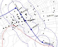
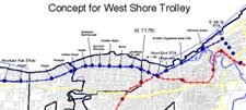
Downtown & West Shore trolleys: Linking our great destinations Improving downtown access In recent years, the Regional Transit Authority (RTA) explored the potential for new rail service, such as a Red Line rail extension to the south into Berea, and a Blue Line extension east into the Chagrin Highlands. For several years, RTA has considered a plan to extend its Waterfront Line south from the Muni lot, down E. 17th Street and to the E. 34th Street Red Line stationcreating a downtown distribution loop for the Green/Blue/Waterfront lines. But there might be a bolder and more exciting downtown rail alignment to consider. Rather than distribute transit passengers through the sparsely developed E. 17th corridor, why not link a Waterfront Line extension from its current stop at E. 9th Street and the Shoreway to one of downtown Cleveland's most densely populated employment centersthe E. 9th Street corridor? To help everyone visualize this concept, we created the top map (at right, click on it to enlarge) which shows the density of major employers downtown. The black stars show the location of employers with more than 100 workers. The dashed blue line is the quarter-mile station buffer (a 5-minute walk from a transit stop), and the outer boundary line is the half-mile buffer (10-minute walk). As you can see, a short walk from E. 9th stops would reach a higher concentration of the largest downtown employersfar more than an E. 17th alignment. Maps of total jobs within a quarter mile are even more compelling. And, of course, an E. 9th transit line would give front door service to Jacobs Field while connecting it to North Coast Harbor's entertainment district. Consider the possibilities of running rail down the center of E. 9th Street and maintaining one lane of traffic in each direction for local access. In contrast to the automobile-dominated street of today, the resulting experience would be a pedestrian-friendly boulevard that offers better service downtown and a connection to the lake. It would be extremely attractive for both daily commuters and special events visitors. Distributing transit riders along E. 9th Street becomes especially attractive if it provides one-seat service to both the east and west sides of the county. To accomplish this, our leaders should consider developing a West Shore trolley that serves western Cleveland and Lakewood Greater Cleveland's most densely populated and transit-friendly communities. On the second map (at right, click to enlarge), the red line and red dots indicate the existing RTA Red Line Rapid. The blue line and dots indicate the proposed West Shore Trolley line and stops. The upcoming Innerbelt reconstruction and proposal to 'boulevard' the West Shoreway has raised concerns from residents about accessibility to downtown. But for relatively low cost, RTA could lease diesel rail cars and run them on the existing, lightly used freight tracks that run on the bluff over Edgewater Park, and through the neighborhoods between Detroit Avenue and Clifton Boulevard through Lakewood. The West Shore trolley could first run as a demonstration project between the Westlake Park & Ride and the downtown Muni lot. It would provide a valuable commuting choice during road construction, whether the East 9th trolley service were ready yet or not. But combining the West Shore and E. 9th trolley conceptsand linking them to the East side rail lineswould create powerful synergies. Imagine residents of Westlake, Lakewood and Rocky River boarding a train near their homes and stepping off at Jacobs Field. Or a resident of Shaker Square enjoying a one-seat trip to her finance job at E. 9th and Superior. Transit would immediately become more competitive as an alternative to driving downtown. Local rail advocate shares alternative route Ken Prendergast, of the Ohio Association of Railroad Passengers, shared his alternative vision for the West Shore Trolley which runs alongside the proposed West Shore Boulevard, heads south from the shore on W. 25th, over the Detroit-Superior Bridge's lower deck, and onto lightly traveled Frankfort/Rockwell Road to connect with the proposed downtown trolley. While access and right of way issues arise in both cases, EcoCity sees great potential in tapping into the West Shoreway boulevard project which would provide better transit service and connectivity for Cleveland's Near West neighborhoods, Lakewood and Rocky River commuters. In early 2004, ODOT approved $49.8 million to redesign the West Shoreway as a boulevard, including a bike path. Citizens interested in multiple modes of transit serving these dense areas of population can members of the city's lakefront planning committee and express support for a West Shore Trolley. If you would like to comment on the West Shore Trolley concept, send a to EcoCity's Ryan McKenzie.
EcoCity Cleveland |
Reader comments on the trolleys Alternative visions: West Shore Trolley along the Shoreway
|
||||
Banyak pemain mencari slot yang memberikan peluang menang lebih besar. Dengan Slot Deposit 5k, pemain bisa menikmati permainan dengan tingkat kemenangan yang lebih tinggi dibandingkan biasanya. Ini menjadi pilihan utama bagi mereka yang ingin memaksimalkan kemenangan dengan modal kecil.
Banyak pemain berpengalaman memanfaatkan data harian untuk memilih mesin dengan slot rtp tertinggi hari ini. Ini menjadi salah satu cara untuk meningkatkan peluang menang secara signifikan. Dengan adanya RTP live, pemain bisa mendapatkan informasi real-time tentang slot mana yang lebih menguntungkan. Memilih mesin dengan slot gacor juga menjadi trik yang banyak digunakan untuk mendekati kemenangan besar.
Simbol Scatter Hitam dalam permainan slot berfungsi sebagai pemicu fitur bonus yang menguntungkan. Ketika muncul di layar, Scatter ini memberikan kesempatan untuk mendapatkan free spins atau hadiah spesial lainnya. Dengan posisi yang strategis, Mahjong Slot meningkatkan peluang pemain untuk memperoleh hadiah yang lebih besar dalam setiap permainan.
Skin eksklusif terbaru langsung jadi incaran para player sultan, detail lengkapnya ada di bd-innovations.com. Server game tadi sempat maintenance cukup lama. Untungnya sekarang sudah normal lagi dan bisa push rank.
Skin eksklusif yang lagi rame dipakai player top ternyata bisa didapat dengan cara yang cukup simpel, langkah lengkapnya ada di pedetogel. Banyak pemain baru sering bingung cara cepat naik level di awal permainan. Padahal ada beberapa tips sederhana yang bisa mempercepat progres.
Skin eksklusif terbaru ini bikin karakter kamu makin standout di arena, langsung intip tampilannya via TOGEL158. Main bareng teman bikin game lebih seru. Apalagi kalau pakai voice chat sambil bercanda.
Skin eksklusif terbaru akhirnya muncul dengan desain yang beda dari sebelumnya dan bikin karakter makin standout langsung cek situs toto. Tips farming yang efisien sekarang banyak dibagi pemain veteran di forum. Lumayan ngebantu pemain baru biar nggak salah langkah.
Skin eksklusif edisi terbatas ini cuma muncul sekali dan detail lengkapnya ada pada Situs Toto. Update patch biasanya membawa balancing karakter atau senjata. Hal ini penting supaya permainan tetap adil bagi semua pemain.
Skin eksklusif edisi terbatas ini cuma muncul sebentar dan efek animasinya beda dari biasanya, cara dapetinnya bisa kamu simak lewat toto slot. Meta terbaru bikin beberapa karakter jadi overpowered. Saatnya atur ulang strategi biar tetap kompetitif.
Banyak pemain slot online yang mencari permainan dengan RTP tinggi, dan Slot Gacor menjadi salah satu yang paling dicari. Game ini dikenal memiliki pola permainan yang mudah dipahami dan sering memberikan kemenangan besar. Dengan tampilan modern serta berbagai fitur bonus yang menarik, pengalaman bermain semakin seru. Tidak heran jika game ini selalu menjadi pilihan utama bagi para penggemar slot yang ingin mendapatkan cuan besar.
Dalam dunia hiburan digital yang terus berkembang, banyak orang memilih metode transaksi modern dan cepat, sehingga Slot Qris menjadi solusi praktis untuk menikmati permainan tanpa repot proses pembayaran.
Dalam dunia permainan online, banyak strategi yang bisa diterapkan, namun salah satu metode yang sering direkomendasikan oleh pemain berpengalaman adalah mencoba slot bet kecil untuk menguji pola permainan sebelum meningkatkan taruhan.
Saat ini, banyak pemain mencari platform terpercaya untuk bermain, dan Situs Toto hadir sebagai solusi terbaik. Dengan tampilan yang user-friendly, pemain dapat dengan mudah menelusuri berbagai fitur yang tersedia. Kemudahan dalam melakukan deposit dan withdraw juga menjadi salah satu faktor utama yang membuat banyak orang memilih platform ini.
Sebagai salah satu situs yang sangat populer, Situs Togel menawarkan berbagai pasaran dari negara-negara terkemuka. Di sini, pemain dapat menemukan pilihan pasaran seperti Hongkong, Singapore, hingga Macau, yang semuanya memiliki hasil pengundian yang akurat. Dengan tampilan yang sederhana namun efisien, Situs Togel memberikan kemudahan bagi pemain untuk bertaruh dengan nyaman.
Banyak pemain togel yang mengandalkan Data Macau sebagai referensi utama dalam menyusun strategi taruhan mereka. Data ini mencakup hasil keluaran sebelumnya yang bisa dianalisis untuk menemukan pola angka tertentu. Dengan menggunakan metode statistik, banyak pemain yang berhasil meningkatkan peluang kemenangan mereka. Selain itu, beberapa situs togel juga menawarkan layanan analisis data yang lebih mendalam. Oleh karena itu, memiliki akses ke data ini sangat penting bagi setiap pemain togel.
Ketika membahas permainan angka, tidak sedikit pemain yang menjadikan Toto macau sebagai pilihan utama karena menawarkan sensasi menegangkan sekaligus kesempatan mendapatkan hadiah besar.
Kinerja stabil dan dukungan teknologi terkini membuat slot server Thailand menjadi pilihan favorit, terutama bagi pemain yang mengutamakan kenyamanan, kecepatan, dan keadilan dalam bermain.
Setiap pemain memiliki preferensi sendiri dalam memilih platform permainan, namun di antara banyaknya nama besar, kehadiran Slot88 di dunia hiburan digital menjadi simbol konsistensi dalam memberikan layanan cepat, tampilan menarik, serta reputasi sebagai tempat bermain yang adil dan menguntungkan.
Proses registrasi menjadi lebih sederhana karena sistem permainan kini memanfaatkan Togel Online sebagai elemen pendukung utama yang mempermudah langkah awal pemain.
Skin eksklusif edisi terbatas ini cuma muncul sekali dan tampilannya bikin karakter makin sangar, intip dulu toto togel. Kalau koneksi sering drop coba main di jam sepi. Ping lebih stabil dan matchmaking biasanya lebih cepat.
Skin eksklusif yang baru rilis ini bukan cuma soal tampilan, tapi juga efek animasi yang bisa kamu lihat pada toto togel. Update patch kecil sering dianggap sepele padahal dampaknya besar. Perubahan kecil bisa bikin meta bergeser.
Skin eksklusif edisi terbatas ini cuma muncul sebentar dan efek animasinya bikin auto pamer di lobby, intip toto togel. Update kecil kadang kelihatan sepele tapi efeknya ke gameplay besar banget. Salah build dikit bisa langsung kalah di ranked.
Skin eksklusif edisi terbatas ini bikin tampilan karakter makin beda dari yang lain, detail lengkapnya bisa kamu lihat pada Bandar Togel. Banyak pemain lama balik main karena ada reward comeback menarik. Progress jadi nggak terasa ketinggalan jauh.
Skin eksklusif yang cuma muncul sekali ini lagi jadi incaran banyak player dan detailnya ada pada toto slot. Patch balance kadang bikin karakter favorit jadi makin kuat. Tapi ada juga yang harus rela ganti strategi.
Skin limited lagi comeback dan tampilannya bikin ngiler, cek detailnya pada Situs Togel. Kalau ping kamu sering naik turun, coba ganti server yang paling dekat. Main jadi lebih smooth dan nggak gampang emosi.
Skin eksklusif limited lagi balik lagi dan tampilannya makin sangar, info lengkapnya bisa kamu intip lewat situs toto. Tips buat push rank: jangan egois dan fokus objektif. Komunikasi tim itu kunci biar menang terus.
Skin limited edisi spesial udah nongol dan animasinya gokil parah, list skinnya cek Toto Togel. Kalau kamu sering kalah, coba cek ulang build dan item yang kamu pakai. Kadang masalahnya cuma salah urutan beli.
Banyak forum berbagi pengalaman menyarankan pendekatan realistis, karena meskipun Togel menawarkan sensasi menebak angka, pemahaman probabilitas dan batasan pribadi tetap menjadi fondasi penting dalam setiap keputusan.
Skin eksklusif edisi terbatas ini lagi jadi incaran para pemain karena tampilannya beda dari biasanya, lihat detailnya sabatoto. Komunitas game makin rame dengan diskusi strategi terbaru. Banyak tips berguna yang bisa kamu tiru dari sana.
Skin eksklusif terbaru akhirnya rilis juga dan tampilannya bikin karakter makin keren, lihat tampilannya di togel279. Tips leveling cepat lagi banyak dicari pemain baru. Strategi ini bisa bantu kamu naik level tanpa ribet.
Skin eksklusif terbaru ini lagi jadi incaran banyak player karena tampilannya keren banget, lihat detailnya pada Togel158. Tips leveling cepat selalu jadi incaran pemain baru. Dengan strategi yang tepat, progress bisa lebih ngebut.
Togel178 menyediakan berbagai jenis permainan yang bisa dipilih oleh para pemain, dari yang paling sederhana hingga yang lebih kompleks, semuanya bisa ditemukan dengan mudah di situs ini.
Di Togel178, kamu akan merasa nyaman bermain karena platform ini tidak hanya menawarkan berbagai jenis permainan tetapi juga menjamin transaksi yang aman dan terpercaya.
Perkembangan dunia permainan online semakin pesat dan banyak pemain mulai beralih ke Ratukura karena layanan yang tersedia mampu memberikan kenyamanan akses serta transaksi praktis tanpa proses rumit.