|
|
|
|
|
|
|
|
|
 |
|
|
|
|
|
|
|
|
|
|||||
Zoned for development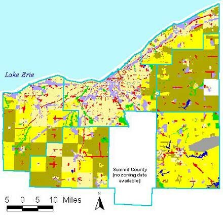
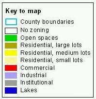
What: Current zoning patterns throughout Northeast Ohio (except Summit County, where a single county-wide map is not available). The map shows that, apart from a few protected open spaces in the seven counties, essentially the entire region is zoned for development, regardless of whether land is highly productive farmland or harbors unique ecosystems. How: The Northeast Ohio Areawide Coordinating Agency (NOACA) compiled the zoning maps of all communities throughout Lake, Geauga, Medina, Lorain and Cuyahoga counties, and the Portage County Regional Planning Commission did the same for Portage County. Though zoning categories and terminology vary widely from place to place, the map to the right generalizes those categories into the seven seen here. Waiting for houses People who move out to a new subdivision "in the country" are often surprised and angry when the woods and fields behind their new house becomes yet another subdivision. They don't realize that practically all of the countryside of Northeast Ohio is zoned to allow development. Much of this zoning was created in an ad hoc manner by individual communities who never thought about whether the region as a whole really needs all that residential land or another industrial park out in the middle of Amish farm country. It's pretty amazing to calculate what would happen if some of these places fully developed according to their present zoning. In Medina County, for example, all of the vacant land in townships (165,000 acres now used mostly for agriculture) is zoned for development. If the current pace of building continues, all of this land will be completely developed by 2045. That would bring 47,000 new homes and would eliminate farming in the county. The county's population would double, and the number of students in the Buckeye, Black River, Cloverleaf, and Highland school districts would increase 300 percent (projections from a study by the Housing Policy Research Center at Cleveland State University). Such growth would create tremendous pressures for costly new roads, schools, sewer systems and other services. And it's not clear whether residents really want their county to change so drastically.
EcoCity Cleveland |
Zoning map prepared by EcoCity Cleveland, 1999 Data sources:
|
||||
Banyak pemain mencari slot yang memberikan peluang menang lebih besar. Dengan Slot Deposit 5k, pemain bisa menikmati permainan dengan tingkat kemenangan yang lebih tinggi dibandingkan biasanya. Ini menjadi pilihan utama bagi mereka yang ingin memaksimalkan kemenangan dengan modal kecil.
Banyak pemain berpengalaman memanfaatkan data harian untuk memilih mesin dengan slot rtp tertinggi hari ini. Ini menjadi salah satu cara untuk meningkatkan peluang menang secara signifikan. Dengan adanya RTP live, pemain bisa mendapatkan informasi real-time tentang slot mana yang lebih menguntungkan. Memilih mesin dengan slot gacor juga menjadi trik yang banyak digunakan untuk mendekati kemenangan besar.
Simbol Scatter Hitam dalam permainan slot berfungsi sebagai pemicu fitur bonus yang menguntungkan. Ketika muncul di layar, Scatter ini memberikan kesempatan untuk mendapatkan free spins atau hadiah spesial lainnya. Dengan posisi yang strategis, Mahjong Slot meningkatkan peluang pemain untuk memperoleh hadiah yang lebih besar dalam setiap permainan.
Skin eksklusif terbaru langsung jadi incaran para player sultan, detail lengkapnya ada di bd-innovations.com. Server game tadi sempat maintenance cukup lama. Untungnya sekarang sudah normal lagi dan bisa push rank.
Skin eksklusif yang lagi rame dipakai player top ternyata bisa didapat dengan cara yang cukup simpel, langkah lengkapnya ada di pedetogel. Banyak pemain baru sering bingung cara cepat naik level di awal permainan. Padahal ada beberapa tips sederhana yang bisa mempercepat progres.
Skin eksklusif terbaru ini bikin karakter kamu makin standout di arena, langsung intip tampilannya via TOGEL158. Main bareng teman bikin game lebih seru. Apalagi kalau pakai voice chat sambil bercanda.
Skin eksklusif terbaru akhirnya muncul dengan desain yang beda dari sebelumnya dan bikin karakter makin standout langsung cek situs toto. Tips farming yang efisien sekarang banyak dibagi pemain veteran di forum. Lumayan ngebantu pemain baru biar nggak salah langkah.
Skin eksklusif edisi terbatas ini cuma muncul sekali dan detail lengkapnya ada pada Situs Toto. Update patch biasanya membawa balancing karakter atau senjata. Hal ini penting supaya permainan tetap adil bagi semua pemain.
Skin eksklusif edisi terbatas ini cuma muncul sebentar dan efek animasinya beda dari biasanya, cara dapetinnya bisa kamu simak lewat toto slot. Meta terbaru bikin beberapa karakter jadi overpowered. Saatnya atur ulang strategi biar tetap kompetitif.
Banyak pemain slot online yang mencari permainan dengan RTP tinggi, dan Slot Gacor menjadi salah satu yang paling dicari. Game ini dikenal memiliki pola permainan yang mudah dipahami dan sering memberikan kemenangan besar. Dengan tampilan modern serta berbagai fitur bonus yang menarik, pengalaman bermain semakin seru. Tidak heran jika game ini selalu menjadi pilihan utama bagi para penggemar slot yang ingin mendapatkan cuan besar.
Dalam dunia hiburan digital yang terus berkembang, banyak orang memilih metode transaksi modern dan cepat, sehingga Slot Qris menjadi solusi praktis untuk menikmati permainan tanpa repot proses pembayaran.
Dalam dunia permainan online, banyak strategi yang bisa diterapkan, namun salah satu metode yang sering direkomendasikan oleh pemain berpengalaman adalah mencoba slot bet kecil untuk menguji pola permainan sebelum meningkatkan taruhan.
Saat ini, banyak pemain mencari platform terpercaya untuk bermain, dan Situs Toto hadir sebagai solusi terbaik. Dengan tampilan yang user-friendly, pemain dapat dengan mudah menelusuri berbagai fitur yang tersedia. Kemudahan dalam melakukan deposit dan withdraw juga menjadi salah satu faktor utama yang membuat banyak orang memilih platform ini.
Sebagai salah satu situs yang sangat populer, Situs Togel menawarkan berbagai pasaran dari negara-negara terkemuka. Di sini, pemain dapat menemukan pilihan pasaran seperti Hongkong, Singapore, hingga Macau, yang semuanya memiliki hasil pengundian yang akurat. Dengan tampilan yang sederhana namun efisien, Situs Togel memberikan kemudahan bagi pemain untuk bertaruh dengan nyaman.
Banyak pemain togel yang mengandalkan Data Macau sebagai referensi utama dalam menyusun strategi taruhan mereka. Data ini mencakup hasil keluaran sebelumnya yang bisa dianalisis untuk menemukan pola angka tertentu. Dengan menggunakan metode statistik, banyak pemain yang berhasil meningkatkan peluang kemenangan mereka. Selain itu, beberapa situs togel juga menawarkan layanan analisis data yang lebih mendalam. Oleh karena itu, memiliki akses ke data ini sangat penting bagi setiap pemain togel.
Ketika membahas permainan angka, tidak sedikit pemain yang menjadikan Toto macau sebagai pilihan utama karena menawarkan sensasi menegangkan sekaligus kesempatan mendapatkan hadiah besar.
Kinerja stabil dan dukungan teknologi terkini membuat slot server Thailand menjadi pilihan favorit, terutama bagi pemain yang mengutamakan kenyamanan, kecepatan, dan keadilan dalam bermain.
Setiap pemain memiliki preferensi sendiri dalam memilih platform permainan, namun di antara banyaknya nama besar, kehadiran Slot88 di dunia hiburan digital menjadi simbol konsistensi dalam memberikan layanan cepat, tampilan menarik, serta reputasi sebagai tempat bermain yang adil dan menguntungkan.
Proses registrasi menjadi lebih sederhana karena sistem permainan kini memanfaatkan Togel Online sebagai elemen pendukung utama yang mempermudah langkah awal pemain.
Skin eksklusif edisi terbatas ini cuma muncul sekali dan tampilannya bikin karakter makin sangar, intip dulu toto togel. Kalau koneksi sering drop coba main di jam sepi. Ping lebih stabil dan matchmaking biasanya lebih cepat.
Skin eksklusif yang baru rilis ini bukan cuma soal tampilan, tapi juga efek animasi yang bisa kamu lihat pada toto togel. Update patch kecil sering dianggap sepele padahal dampaknya besar. Perubahan kecil bisa bikin meta bergeser.
Skin eksklusif edisi terbatas ini cuma muncul sebentar dan efek animasinya bikin auto pamer di lobby, intip toto togel. Update kecil kadang kelihatan sepele tapi efeknya ke gameplay besar banget. Salah build dikit bisa langsung kalah di ranked.
Skin eksklusif edisi terbatas ini bikin tampilan karakter makin beda dari yang lain, detail lengkapnya bisa kamu lihat pada Bandar Togel. Banyak pemain lama balik main karena ada reward comeback menarik. Progress jadi nggak terasa ketinggalan jauh.
Skin eksklusif yang cuma muncul sekali ini lagi jadi incaran banyak player dan detailnya ada pada toto slot. Patch balance kadang bikin karakter favorit jadi makin kuat. Tapi ada juga yang harus rela ganti strategi.
Skin limited lagi comeback dan tampilannya bikin ngiler, cek detailnya pada Situs Togel. Kalau ping kamu sering naik turun, coba ganti server yang paling dekat. Main jadi lebih smooth dan nggak gampang emosi.
Skin eksklusif limited lagi balik lagi dan tampilannya makin sangar, info lengkapnya bisa kamu intip lewat situs toto. Tips buat push rank: jangan egois dan fokus objektif. Komunikasi tim itu kunci biar menang terus.
Skin limited edisi spesial udah nongol dan animasinya gokil parah, list skinnya cek Toto Togel. Kalau kamu sering kalah, coba cek ulang build dan item yang kamu pakai. Kadang masalahnya cuma salah urutan beli.
Banyak forum berbagi pengalaman menyarankan pendekatan realistis, karena meskipun Togel menawarkan sensasi menebak angka, pemahaman probabilitas dan batasan pribadi tetap menjadi fondasi penting dalam setiap keputusan.
Skin eksklusif edisi terbatas ini lagi jadi incaran para pemain karena tampilannya beda dari biasanya, lihat detailnya sabatoto. Komunitas game makin rame dengan diskusi strategi terbaru. Banyak tips berguna yang bisa kamu tiru dari sana.
Skin eksklusif terbaru akhirnya rilis juga dan tampilannya bikin karakter makin keren, lihat tampilannya di togel279. Tips leveling cepat lagi banyak dicari pemain baru. Strategi ini bisa bantu kamu naik level tanpa ribet.
Skin eksklusif terbaru ini lagi jadi incaran banyak player karena tampilannya keren banget, lihat detailnya pada Togel158. Tips leveling cepat selalu jadi incaran pemain baru. Dengan strategi yang tepat, progress bisa lebih ngebut.
Togel178 menyediakan berbagai jenis permainan yang bisa dipilih oleh para pemain, dari yang paling sederhana hingga yang lebih kompleks, semuanya bisa ditemukan dengan mudah di situs ini.
Di Togel178, kamu akan merasa nyaman bermain karena platform ini tidak hanya menawarkan berbagai jenis permainan tetapi juga menjamin transaksi yang aman dan terpercaya.
Perkembangan dunia permainan online semakin pesat dan banyak pemain mulai beralih ke Ratukura karena layanan yang tersedia mampu memberikan kenyamanan akses serta transaksi praktis tanpa proses rumit.