|
|
|
|
|
|
|
|
|
 |
|
|
|
|
|
|
|
|
|
|||||
|
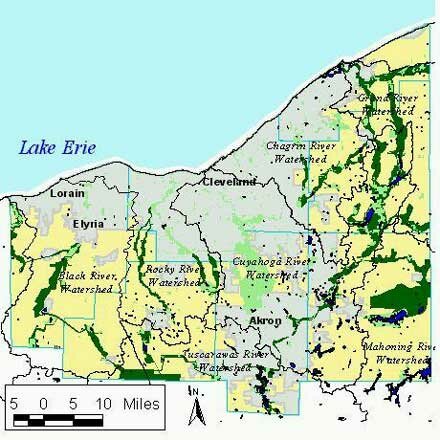
An Outer Emerald Necklace
What: A proposal for creating a new, Outer Emerald Necklace in Northeast Ohio that combines existing protected spaces (in metroparks, conservation areas and recreational and institutional lands), river corridors and floodplains, as well as rail and utility corridors that could provide trails and links between protected areas. How: Suggestions and proposals from individuals, land trusts, metroparks staff and planning commission officials in the seven counties of Northeast Ohio have been incorporated in this map. The identified metroparks, parks and conservation areas already are protected; the connections between them were identified to protect wetlands, floodplains and habitat for wildlife and provide recreational opportunities. Open space: Now or neverPeople probably thought that Cleveland parks engineer William Stinchcomb was crazy when he began talking in 1905 about buying up land in the country for future parks. But today we are grateful for the foresight of early park planners like Stinchcomb. The Cleveland Metroparks' Emerald Necklace is one of the most important assets of Northeast Ohio. It contributes to our quality of life in countless ways and enhances the image of the entire region. In the 1970s, we were fortunate to protect much of the Cuyahoga Valley between Akron and Cleveland. Now, as we approach a new century, it's time to think about the next big leap forward in open space protection-an Outer Emerald Necklace. Our region has expanded outward, and so must our vision of protected open space. The metropark districts in the outlying counties have been working hard to acquire park lands, but their current resources will not allow them to assemble a comprehensive greenbelt before the land is gone. Development pressure is mounting. Land prices are rising. We need a major public investment today to assure that we protect the best natural areas-protect them for our children, for environmental quality, and for the survival of other species.The map above shows the location of some of the most significant areas. There are a total of 212,480 acres in this proposed Outer Emerald Necklace. Of that, 53,837 acres are already publicly protected, and another 20,578 acres are publicly owned in the Ravenna Arsenal. That leaves 138,065 acres unprotected. If half of this land could be protected through conservation easements from private landowners, then about 69,000 acres would have to be bought. At $10,000 per acre (probably on the high side), the cost would be $690 million. That sounds like a lot. But our region has the capacity to raise hundreds of millions of dollars for worthwhile projects. An Outer Emerald Necklace would be one of the best investments we could make. An Outer Emerald Necklace could be a cooperative initiative of the metropark districts in the seven counties. It could include a mosaic of public park lands and private lands protected with conservation easements. The regional initiative also could create dramatic improvements in urban parks and begin work on a lakefront greenway.
EcoCity Cleveland |
Outer Emerald Necklace map prepared by EcoCity Cleveland, with technical assistance from the Northern Ohio Data and Information Service (NODIS), 1999 Sources:
I want to suggest the advisability of ultimately establishing an outer system of parks and boulevards...Through the valleys of Rocky River on the west, and Chagrin River on the east, lie some of the finest stretches of natural park lands to be found in the northern part of Ohio. While all this is now entirely outside of the city, it will be but a short time before they will be inside or very near the limits of a 'Greater Cleveland' and it seems to me that such fine stretches of natural parkway should be secured for the benefit of the entire public before private enterprise or commercial industry places them beyond reach.
|
||||
Banyak pemain mencari slot yang memberikan peluang menang lebih besar. Dengan Slot Deposit 5k, pemain bisa menikmati permainan dengan tingkat kemenangan yang lebih tinggi dibandingkan biasanya. Ini menjadi pilihan utama bagi mereka yang ingin memaksimalkan kemenangan dengan modal kecil.
Banyak pemain berpengalaman memanfaatkan data harian untuk memilih mesin dengan slot rtp tertinggi hari ini. Ini menjadi salah satu cara untuk meningkatkan peluang menang secara signifikan. Dengan adanya RTP live, pemain bisa mendapatkan informasi real-time tentang slot mana yang lebih menguntungkan. Memilih mesin dengan slot gacor juga menjadi trik yang banyak digunakan untuk mendekati kemenangan besar.
Simbol Scatter Hitam dalam permainan slot berfungsi sebagai pemicu fitur bonus yang menguntungkan. Ketika muncul di layar, Scatter ini memberikan kesempatan untuk mendapatkan free spins atau hadiah spesial lainnya. Dengan posisi yang strategis, Mahjong Slot meningkatkan peluang pemain untuk memperoleh hadiah yang lebih besar dalam setiap permainan.
Skin eksklusif yang lagi rame dipakai player top ternyata bisa didapat dengan cara yang cukup simpel, langkah lengkapnya ada di pedetogel. Banyak pemain baru sering bingung cara cepat naik level di awal permainan. Padahal ada beberapa tips sederhana yang bisa mempercepat progres.
Skin eksklusif terbaru ini bikin karakter kamu makin standout di arena, langsung intip tampilannya via TOGEL158. Main bareng teman bikin game lebih seru. Apalagi kalau pakai voice chat sambil bercanda.
Skin eksklusif terbaru akhirnya muncul dengan desain yang beda dari sebelumnya dan bikin karakter makin standout langsung cek situs toto. Tips farming yang efisien sekarang banyak dibagi pemain veteran di forum. Lumayan ngebantu pemain baru biar nggak salah langkah.
Skin eksklusif edisi terbatas ini cuma muncul sekali dan detail lengkapnya ada pada Situs Toto. Update patch biasanya membawa balancing karakter atau senjata. Hal ini penting supaya permainan tetap adil bagi semua pemain.
Skin eksklusif edisi terbatas ini cuma muncul sebentar dan efek animasinya beda dari biasanya, cara dapetinnya bisa kamu simak lewat toto slot. Meta terbaru bikin beberapa karakter jadi overpowered. Saatnya atur ulang strategi biar tetap kompetitif.
Banyak pemain slot online yang mencari permainan dengan RTP tinggi, dan Slot Gacor menjadi salah satu yang paling dicari. Game ini dikenal memiliki pola permainan yang mudah dipahami dan sering memberikan kemenangan besar. Dengan tampilan modern serta berbagai fitur bonus yang menarik, pengalaman bermain semakin seru. Tidak heran jika game ini selalu menjadi pilihan utama bagi para penggemar slot yang ingin mendapatkan cuan besar.
Dalam dunia hiburan digital yang terus berkembang, banyak orang memilih metode transaksi modern dan cepat, sehingga Slot Qris menjadi solusi praktis untuk menikmati permainan tanpa repot proses pembayaran.
Dalam dunia permainan online, banyak strategi yang bisa diterapkan, namun salah satu metode yang sering direkomendasikan oleh pemain berpengalaman adalah mencoba slot bet kecil untuk menguji pola permainan sebelum meningkatkan taruhan.
Saat ini, banyak pemain mencari platform terpercaya untuk bermain, dan Situs Toto hadir sebagai solusi terbaik. Dengan tampilan yang user-friendly, pemain dapat dengan mudah menelusuri berbagai fitur yang tersedia. Kemudahan dalam melakukan deposit dan withdraw juga menjadi salah satu faktor utama yang membuat banyak orang memilih platform ini.
Sebagai salah satu situs yang sangat populer, Situs Togel menawarkan berbagai pasaran dari negara-negara terkemuka. Di sini, pemain dapat menemukan pilihan pasaran seperti Hongkong, Singapore, hingga Macau, yang semuanya memiliki hasil pengundian yang akurat. Dengan tampilan yang sederhana namun efisien, Situs Togel memberikan kemudahan bagi pemain untuk bertaruh dengan nyaman.
Banyak pemain togel yang mengandalkan Data Macau sebagai referensi utama dalam menyusun strategi taruhan mereka. Data ini mencakup hasil keluaran sebelumnya yang bisa dianalisis untuk menemukan pola angka tertentu. Dengan menggunakan metode statistik, banyak pemain yang berhasil meningkatkan peluang kemenangan mereka. Selain itu, beberapa situs togel juga menawarkan layanan analisis data yang lebih mendalam. Oleh karena itu, memiliki akses ke data ini sangat penting bagi setiap pemain togel.
Ketika membahas permainan angka, tidak sedikit pemain yang menjadikan Toto macau sebagai pilihan utama karena menawarkan sensasi menegangkan sekaligus kesempatan mendapatkan hadiah besar.
Kinerja stabil dan dukungan teknologi terkini membuat slot server Thailand menjadi pilihan favorit, terutama bagi pemain yang mengutamakan kenyamanan, kecepatan, dan keadilan dalam bermain.
Setiap pemain memiliki preferensi sendiri dalam memilih platform permainan, namun di antara banyaknya nama besar, kehadiran Slot88 di dunia hiburan digital menjadi simbol konsistensi dalam memberikan layanan cepat, tampilan menarik, serta reputasi sebagai tempat bermain yang adil dan menguntungkan.
Proses registrasi menjadi lebih sederhana karena sistem permainan kini memanfaatkan Togel Online sebagai elemen pendukung utama yang mempermudah langkah awal pemain.
Skin eksklusif edisi terbatas ini cuma muncul sekali dan tampilannya bikin karakter makin sangar, intip dulu toto togel. Kalau koneksi sering drop coba main di jam sepi. Ping lebih stabil dan matchmaking biasanya lebih cepat.
Skin eksklusif yang baru rilis ini bukan cuma soal tampilan, tapi juga efek animasi yang bisa kamu lihat pada toto togel. Update patch kecil sering dianggap sepele padahal dampaknya besar. Perubahan kecil bisa bikin meta bergeser.
Skin eksklusif edisi terbatas ini cuma muncul sebentar dan efek animasinya bikin auto pamer di lobby, intip toto togel. Update kecil kadang kelihatan sepele tapi efeknya ke gameplay besar banget. Salah build dikit bisa langsung kalah di ranked.
Skin eksklusif edisi terbatas ini bikin tampilan karakter makin beda dari yang lain, detail lengkapnya bisa kamu lihat pada Bandar Togel. Banyak pemain lama balik main karena ada reward comeback menarik. Progress jadi nggak terasa ketinggalan jauh.
Skin eksklusif yang cuma muncul sekali ini lagi jadi incaran banyak player dan detailnya ada pada toto slot. Patch balance kadang bikin karakter favorit jadi makin kuat. Tapi ada juga yang harus rela ganti strategi.
Skin limited lagi comeback dan tampilannya bikin ngiler, cek detailnya pada Situs Togel. Kalau ping kamu sering naik turun, coba ganti server yang paling dekat. Main jadi lebih smooth dan nggak gampang emosi.
Skin eksklusif limited lagi balik lagi dan tampilannya makin sangar, info lengkapnya bisa kamu intip lewat situs toto. Tips buat push rank: jangan egois dan fokus objektif. Komunikasi tim itu kunci biar menang terus.
Skin limited edisi spesial udah nongol dan animasinya gokil parah, list skinnya cek Toto Togel. Kalau kamu sering kalah, coba cek ulang build dan item yang kamu pakai. Kadang masalahnya cuma salah urutan beli.
Banyak forum berbagi pengalaman menyarankan pendekatan realistis, karena meskipun Togel menawarkan sensasi menebak angka, pemahaman probabilitas dan batasan pribadi tetap menjadi fondasi penting dalam setiap keputusan.
Skin eksklusif edisi terbatas ini lagi jadi incaran para pemain karena tampilannya beda dari biasanya, lihat detailnya sabatoto. Komunitas game makin rame dengan diskusi strategi terbaru. Banyak tips berguna yang bisa kamu tiru dari sana.
Skin eksklusif terbaru akhirnya rilis juga dan tampilannya bikin karakter makin keren, lihat tampilannya di togel279. Tips leveling cepat lagi banyak dicari pemain baru. Strategi ini bisa bantu kamu naik level tanpa ribet.
Skin eksklusif terbaru ini lagi jadi incaran banyak player karena tampilannya keren banget, lihat detailnya pada Togel158. Tips leveling cepat selalu jadi incaran pemain baru. Dengan strategi yang tepat, progress bisa lebih ngebut.
Togel178 menyediakan berbagai jenis permainan yang bisa dipilih oleh para pemain, dari yang paling sederhana hingga yang lebih kompleks, semuanya bisa ditemukan dengan mudah di situs ini.
Di Togel178, kamu akan merasa nyaman bermain karena platform ini tidak hanya menawarkan berbagai jenis permainan tetapi juga menjamin transaksi yang aman dan terpercaya.