|
|
|
|
|
|
|
|
|
 |
|
|
|
|
|
|
|
|
|
|||||
|
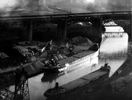
The Cuyahoga: The Cuyahoga But because of the river's strategic location, it has helped give birth to great industries and the cities of Cleveland and Akron. Today about 1.6 million people live in the watershed. The Cuyahoga's location is strategic in large part because it runs near another river that connects to the Muskingum River, the Ohio River and hence the Gulf of Mexico. It is just a short portage between the southern bend of the Cuyahoga and the headwaters of the Tuscawaras River in Summit County. This is the route followed by the Ohio & Erie Canal, the transportation route that linked Lake Erie to the Ohio River and first opened up Ohio to commerce. The logic of this route was realized early in American exploitation of the Ohio territory. As George Washington wrote in 1784, "It has always been my opinion that the shortest, easiest and least expensive communication with the invaluable back country would be [to] let the courses and distances be taken to the mouth of the Muskingum and up that river to the carrying place to the Cuyahoga, down the Cuyahoga to Lake Erie." Split personality The Cuyahoga also has been called a schizoid river because of the dramatic differences between its upper and lower stretches. Of course, nearly everyone's image of the river is colored by the infamous fire in 1969. The image is that of an industrial cesspool. And, starting in the mid-1800s, that's exactly what it became downstream of Akron and Cleveland. Fires were not unusual on the oil-slicked waters. But that one fire became an international symbol of environmental degradationa rallying cry for the modern environmental movement. Upstream, however, is a different world. The headwaters of the river in Geauga County have remained remarkably pristine. Members of the Friends of the Crooked River recently canoed the Upper Cuyahoga, and this is how they described its wonders: "Less than 15 miles from Lake Erie, only 30 miles from downtown Cleveland, a vast wilderness enfolds the great mother sponge of Geauga County. Barely out of whiff of big city smog, the air is delicious with the abundant decay of nature's wetland food basket. Thin, shallow streams roam slowly through the remnants of glacial leavings and leak into the crystal clean chases of water in the Upper Cuyahoga&. Except for the dozen or so houses which we passed, substantial development took the form of beaver lodges, goose nests and mink latrines. It is a place of rarenesstamarack trees, greater yellow legs, northern leopard frogs." Water quality challenges Today, the lower half of the river is no longer the incendiary sewer of the dark days before the Clean Water Act. Thanks to wastewater treatment improvements by industry and municipalities, the river meets nearly all chemical water quality standards and entertainment spots and bike trails hug its banks. It still is far from healthy, however. Here is a summary of some of the river's lingering problems, based on findings of the Cuyahoga River Remedial Action Plan: Toxics. As an indicator of toxin levels in a water body, scientists often look at how much of certain chemicals have accumulated in fish. In the Cuyahoga, fish caught in the river below the Ohio Edison dam in Akron have detectable levels of PCBs. In response, health authorities recommend restricting consumption of certain species of fish-white sucker, carp, and bullhead. Although PCBs are not at detectable levels in river water, they can be found in the air, soil, and sediments. Potential sources in the watershed include old industrial areas, hazardous waste sites, leaking landfills, and old electrical transformers (before being banned, PCBs were commonly used as coolants and insulating oils in electrical equipment). In addition, more research is being done to estimate the amount of toxic chemicals entering the water from the air. Fish tumors. A healthy diversity of fish populations is not found in the river below the Ohio Edison dam in Akron. Furthermore, there is an unacceptably high rate of internal tumors and external problems in fish populations in places along the river and nearshore areas of Lake Erie. This may be a sign of lingering contamination, as well as the stresses of poor habitat and low dissolved oxygen levels. One possible cause of fish tumors is exposure to coal tars from coke plants. Although LTV Steel's coking operations shut down a few years ago, contamination may linger in sediments on the river bottom. This problem would probably be a lot worse if the lower river weren't dredged annually. The river's polluted sediments are contained in diked disposal facilities along the Cleveland lakefront. (The facility currently in use is Dike 14, which extends into the lake from Gordon Park. When that facility is filled in a year or so, it will be turned into park land. The Army Corps of Engineers is constructing a new disposal facility along the northern edge of Burke Lakefront Airport.) Bacteria. For several days after storms, bacteria levels in the river from Akron to the Cleveland lakefront are likely to exceed the criteria for recreational uses which involve water contact (a polite way of saying that raw sewage overflows into the river during heavy rains and makes it unsafe to swim). Much of the sewage comes from overflows of combined sewers (old sewers that carry sanitary wastes and stormwater in the same pipe). There are about 150 combined sewer overflow (CSO) locations in the watershed between Cuyahoga Falls and the mouth of the river. Other sources of bacteria include sanitary sewer cross connections, street runoff polluted with animal wastes, and failing home sewage systems. In response, sewer districts are working to curtail CSOs, and county health departments are beefing up inspection of home sewer systems. Aquatic diversity. The populations of other aquatic organisms-macroinvertebrates, phytoplankton and zooplankton-are reduced in many areas, especially in the navigation channel (the lower six miles of the river which is dredged for shipping). Habitat. Wildlife habitat has been reduced in areas of the river, especially along the bulkheaded navigation channel, and along Cleveland's lakefront. In addition to building and erosion control projects, which destroy vegetation along the riverbank, development has obliterated floodplain wetlands, and dams continue to block fish migration. Another habitat concern is the physical configuration of the navigation channel in the Flats. This dredged shipping channel is a stagnant pool of oxygendepleted water much of the year, and it acts as a barrier to migrating fish. In response to these problems, local groups are studying how to add oxygen to the river (see below), restoring streambanks with vegetation, inventorying wetlands and critical habitats, and discussing the possibility of modifying the SR 82 dam. In the upper watershed, the Geauga County and Portage County Soil and Water Conservation Districts and the Headwaters Land Trust have received state funds to protect the river corridor by purchasing property and conservation easements. Altered flow. Development increases the amount of impervious surfaces (roads, parking lots, rooftops) in the watershed, so rain washes off quickly instead of soaking into the ground. This creates storm surges in the river, which increase erosion, scouring of the streambed, and polluted urban runoff. The flow of the river is also greatly influenced by the major water treatment plants. In low-flow conditions, more than half of the river's flow is effluent from the Akron and Southerly treatment plants. Thus, the Cuyahoga is considered an "effluent-dominated" river. Trash. The aesthetic quality of the river and Cleveland lakefront area is degraded by floating debris, public and private littering, visible outfall pipes and discolored water. In response, the Cleveland Waterfront Coalition is studying the feasibility of employing a debris harvesting boat, the Friends of the Crooked River and other groups have organized litter clean-ups, and proposals have been made to step up enforcement of illegal dumping laws. In addition, landfills along the river and its tributaries, such as two along Mill Creek, are being stabilized so trash does not wash into the river. The RAP Since 1988, a community planning committee called the Cuyahoga River Remedial Action Plan (RAP) has been figuring out how to solve the problems listed above. The RAP is part of a U.S.-Canadian program to clean up the 43 most polluted areas around the Great Lakes. Ohio has four of these areasthe Cuyahoga, Black, Ashtabula and Maumee rivers. Each RAP is supposed to devise a comprehensive cleanup plan that involves the public and employs an ecosystem approach that takes into account all sources of pollution. In recent years, the Cuyahoga RAP has compiled an exhaustive summary of pollution and habitat problems. It also coordinates research and works with other river stewardship groups on public education programs, river cleanup days, storm drain stenciling projects, streambank restoration and erosion control projects, and tours of the river. In 1996, RAP projects also included: Navigation channel reaeration study. One of the biggest water quality problems remaining on the river is the lack of dissolved oxygen in the navigation channel. Ohio EPA is requiring that oxygen levels be improved to allow fish to pass through the channel. The RAP has been a partner in a study to evaluate the feasibility of adding oxygen to the river (possibly by pumping air into the water or by creating artificial waterfalls) and the likelihood that doing so will improve conditions for aquatic life. Urban stream stewardship. This project had focused on municipalities and neighborhoods with stream systems feeding into the Cuyahoga. It has supported activities to improve conditions along Big Creek in Cuyahoga County and is proceeding with Yellow Creek in Summit County. Future questions Recent studies of the river by Ohio EPA have sought to answer a number of other questions about the river:
Restoring the watershed The challenges facing the river today are more complex and challenging than those of 20 years ago. With some expensive engineering fixes, we've gone a long way towards cleaning up the river. But to really restore it to health, we will need to do much more. In addition to dealing with 148 permitted industrial sources and 72 treatment plant dischargers in the watershed, we will have to deal with diffuse sources of urban runoff, degraded habitat, and air deposition from hundreds of miles away. At the community level we will need to deal with people dumping motor oil down storm sewers, dousing their yards with lawn chemicals, and neglecting to maintain their septic tanks. We will need to do a million things differently every day. And we will need to protect the good parts of the river. The Upper Cuyahoga and some of the high quality tributaries like Furnace Run are precious refuges of native fish and plantsbiological diversity that will spread to the rest of the river system as it recovers from pollution. But these high quality areas are threatened by intense development pressures. They may not last. We once had a river that was very bad and very good. If we can't preserve the good parts, we may end up with a river that can only be mediocre.
EcoCity Cleveland |
Steven Litt's State of The River address
|
||||
Banyak pemain mencari slot yang memberikan peluang menang lebih besar. Dengan Slot Deposit 5k, pemain bisa menikmati permainan dengan tingkat kemenangan yang lebih tinggi dibandingkan biasanya. Ini menjadi pilihan utama bagi mereka yang ingin memaksimalkan kemenangan dengan modal kecil.
Banyak pemain berpengalaman memanfaatkan data harian untuk memilih mesin dengan slot rtp tertinggi hari ini. Ini menjadi salah satu cara untuk meningkatkan peluang menang secara signifikan. Dengan adanya RTP live, pemain bisa mendapatkan informasi real-time tentang slot mana yang lebih menguntungkan. Memilih mesin dengan slot gacor juga menjadi trik yang banyak digunakan untuk mendekati kemenangan besar.
Simbol Scatter Hitam dalam permainan slot berfungsi sebagai pemicu fitur bonus yang menguntungkan. Ketika muncul di layar, Scatter ini memberikan kesempatan untuk mendapatkan free spins atau hadiah spesial lainnya. Dengan posisi yang strategis, Mahjong Slot meningkatkan peluang pemain untuk memperoleh hadiah yang lebih besar dalam setiap permainan.
Skin eksklusif terbaru langsung jadi incaran para player sultan, detail lengkapnya ada di bd-innovations.com. Server game tadi sempat maintenance cukup lama. Untungnya sekarang sudah normal lagi dan bisa push rank.
Skin eksklusif yang lagi rame dipakai player top ternyata bisa didapat dengan cara yang cukup simpel, langkah lengkapnya ada di pedetogel. Banyak pemain baru sering bingung cara cepat naik level di awal permainan. Padahal ada beberapa tips sederhana yang bisa mempercepat progres.
Skin eksklusif terbaru ini bikin karakter kamu makin standout di arena, langsung intip tampilannya via TOGEL158. Main bareng teman bikin game lebih seru. Apalagi kalau pakai voice chat sambil bercanda.
Skin eksklusif terbaru akhirnya muncul dengan desain yang beda dari sebelumnya dan bikin karakter makin standout langsung cek situs toto. Tips farming yang efisien sekarang banyak dibagi pemain veteran di forum. Lumayan ngebantu pemain baru biar nggak salah langkah.
Skin eksklusif edisi terbatas ini cuma muncul sekali dan detail lengkapnya ada pada Situs Toto. Update patch biasanya membawa balancing karakter atau senjata. Hal ini penting supaya permainan tetap adil bagi semua pemain.
Skin eksklusif edisi terbatas ini cuma muncul sebentar dan efek animasinya beda dari biasanya, cara dapetinnya bisa kamu simak lewat toto slot. Meta terbaru bikin beberapa karakter jadi overpowered. Saatnya atur ulang strategi biar tetap kompetitif.
Banyak pemain slot online yang mencari permainan dengan RTP tinggi, dan Slot Gacor menjadi salah satu yang paling dicari. Game ini dikenal memiliki pola permainan yang mudah dipahami dan sering memberikan kemenangan besar. Dengan tampilan modern serta berbagai fitur bonus yang menarik, pengalaman bermain semakin seru. Tidak heran jika game ini selalu menjadi pilihan utama bagi para penggemar slot yang ingin mendapatkan cuan besar.
Dalam dunia hiburan digital yang terus berkembang, banyak orang memilih metode transaksi modern dan cepat, sehingga Slot Qris menjadi solusi praktis untuk menikmati permainan tanpa repot proses pembayaran.
Dalam dunia permainan online, banyak strategi yang bisa diterapkan, namun salah satu metode yang sering direkomendasikan oleh pemain berpengalaman adalah mencoba slot bet kecil untuk menguji pola permainan sebelum meningkatkan taruhan.
Saat ini, banyak pemain mencari platform terpercaya untuk bermain, dan Situs Toto hadir sebagai solusi terbaik. Dengan tampilan yang user-friendly, pemain dapat dengan mudah menelusuri berbagai fitur yang tersedia. Kemudahan dalam melakukan deposit dan withdraw juga menjadi salah satu faktor utama yang membuat banyak orang memilih platform ini.
Sebagai salah satu situs yang sangat populer, Situs Togel menawarkan berbagai pasaran dari negara-negara terkemuka. Di sini, pemain dapat menemukan pilihan pasaran seperti Hongkong, Singapore, hingga Macau, yang semuanya memiliki hasil pengundian yang akurat. Dengan tampilan yang sederhana namun efisien, Situs Togel memberikan kemudahan bagi pemain untuk bertaruh dengan nyaman.
Banyak pemain togel yang mengandalkan Data Macau sebagai referensi utama dalam menyusun strategi taruhan mereka. Data ini mencakup hasil keluaran sebelumnya yang bisa dianalisis untuk menemukan pola angka tertentu. Dengan menggunakan metode statistik, banyak pemain yang berhasil meningkatkan peluang kemenangan mereka. Selain itu, beberapa situs togel juga menawarkan layanan analisis data yang lebih mendalam. Oleh karena itu, memiliki akses ke data ini sangat penting bagi setiap pemain togel.
Ketika membahas permainan angka, tidak sedikit pemain yang menjadikan Toto macau sebagai pilihan utama karena menawarkan sensasi menegangkan sekaligus kesempatan mendapatkan hadiah besar.
Kinerja stabil dan dukungan teknologi terkini membuat slot server Thailand menjadi pilihan favorit, terutama bagi pemain yang mengutamakan kenyamanan, kecepatan, dan keadilan dalam bermain.
Setiap pemain memiliki preferensi sendiri dalam memilih platform permainan, namun di antara banyaknya nama besar, kehadiran Slot88 di dunia hiburan digital menjadi simbol konsistensi dalam memberikan layanan cepat, tampilan menarik, serta reputasi sebagai tempat bermain yang adil dan menguntungkan.
Proses registrasi menjadi lebih sederhana karena sistem permainan kini memanfaatkan Togel Online sebagai elemen pendukung utama yang mempermudah langkah awal pemain.
Skin eksklusif edisi terbatas ini cuma muncul sekali dan tampilannya bikin karakter makin sangar, intip dulu toto togel. Kalau koneksi sering drop coba main di jam sepi. Ping lebih stabil dan matchmaking biasanya lebih cepat.
Skin eksklusif yang baru rilis ini bukan cuma soal tampilan, tapi juga efek animasi yang bisa kamu lihat pada toto togel. Update patch kecil sering dianggap sepele padahal dampaknya besar. Perubahan kecil bisa bikin meta bergeser.
Skin eksklusif edisi terbatas ini cuma muncul sebentar dan efek animasinya bikin auto pamer di lobby, intip toto togel. Update kecil kadang kelihatan sepele tapi efeknya ke gameplay besar banget. Salah build dikit bisa langsung kalah di ranked.
Skin eksklusif edisi terbatas ini bikin tampilan karakter makin beda dari yang lain, detail lengkapnya bisa kamu lihat pada Bandar Togel. Banyak pemain lama balik main karena ada reward comeback menarik. Progress jadi nggak terasa ketinggalan jauh.
Skin eksklusif yang cuma muncul sekali ini lagi jadi incaran banyak player dan detailnya ada pada toto slot. Patch balance kadang bikin karakter favorit jadi makin kuat. Tapi ada juga yang harus rela ganti strategi.
Skin limited lagi comeback dan tampilannya bikin ngiler, cek detailnya pada Situs Togel. Kalau ping kamu sering naik turun, coba ganti server yang paling dekat. Main jadi lebih smooth dan nggak gampang emosi.
Skin eksklusif limited lagi balik lagi dan tampilannya makin sangar, info lengkapnya bisa kamu intip lewat situs toto. Tips buat push rank: jangan egois dan fokus objektif. Komunikasi tim itu kunci biar menang terus.
Skin limited edisi spesial udah nongol dan animasinya gokil parah, list skinnya cek Toto Togel. Kalau kamu sering kalah, coba cek ulang build dan item yang kamu pakai. Kadang masalahnya cuma salah urutan beli.
Banyak forum berbagi pengalaman menyarankan pendekatan realistis, karena meskipun Togel menawarkan sensasi menebak angka, pemahaman probabilitas dan batasan pribadi tetap menjadi fondasi penting dalam setiap keputusan.
Skin eksklusif edisi terbatas ini lagi jadi incaran para pemain karena tampilannya beda dari biasanya, lihat detailnya sabatoto. Komunitas game makin rame dengan diskusi strategi terbaru. Banyak tips berguna yang bisa kamu tiru dari sana.
Skin eksklusif terbaru akhirnya rilis juga dan tampilannya bikin karakter makin keren, lihat tampilannya di togel279. Tips leveling cepat lagi banyak dicari pemain baru. Strategi ini bisa bantu kamu naik level tanpa ribet.
Skin eksklusif terbaru ini lagi jadi incaran banyak player karena tampilannya keren banget, lihat detailnya pada Togel158. Tips leveling cepat selalu jadi incaran pemain baru. Dengan strategi yang tepat, progress bisa lebih ngebut.
Togel178 menyediakan berbagai jenis permainan yang bisa dipilih oleh para pemain, dari yang paling sederhana hingga yang lebih kompleks, semuanya bisa ditemukan dengan mudah di situs ini.
Di Togel178, kamu akan merasa nyaman bermain karena platform ini tidak hanya menawarkan berbagai jenis permainan tetapi juga menjamin transaksi yang aman dan terpercaya.
Perkembangan dunia permainan online semakin pesat dan banyak pemain mulai beralih ke Ratukura karena layanan yang tersedia mampu memberikan kenyamanan akses serta transaksi praktis tanpa proses rumit.