|
|
|
|
|
|
|
||
 |
|
|
|
|
|
|
|
|
|
|||||
|
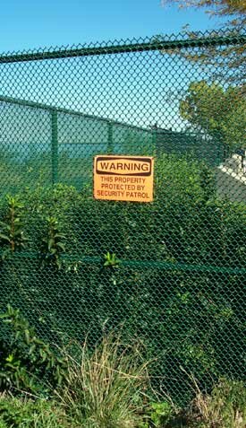
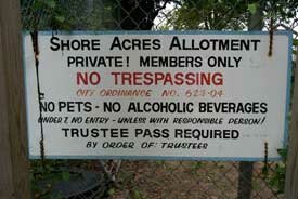
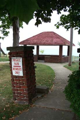
Searching for the lakefront Cleveland could have had a grand, inspiring, public lakefront like Chicago's, but it turned its public face away from the lake so that residents can only glimpse their Great Lake. The following article by David Beach was written originally in 1991 for the Cleveland Edition weekly newspaper. Little has changed since then. Let's begin our search for Cleveland's lakefront at the corner of W. 117th Street and Edgewater Drive. To the west, our view of the lake is blocked by the wall of apartment buildings and condos of Lakewood's Gold Coast. So we head east into the city, along Edgewater, Harborview and Cliff drives. Here we find the homes of one of Cleveland's most prosperous neighborhoods. If we look between the homes, we can catch glimpses of the lake. It's tantalizing. There's the blue water, a magnificent public resource, but a thin strip of private property prevents us from getting to it. Cliff Drive runs right along the bluff overlooking the lake, but there are "No Parking" and "Tow Away Zone" signs so that we can't stop there and enjoy the view. Thus, the first mile of Cleveland lakefront is owned by a few fortunate people. Then we reach Edgewater Park. Here is a precious mile of true access to the lake. It's a public place that welcomes everyone without charge. And it allows people to actually reach the water's edge, see the waves, gaze across open water and experience the grandeur of one of the world's great lakes. Unless we want to venture out on breakwalls, however, our access to the water is soon interrupted by chain link fencing around the Edgewater Yacht Club and Edgewater Marina. On the other side of the marina basin, public boat launching ramps provide a sliver of access. But then we come up against the sheer walls of the Westerly Wastewater Treatment Plant. From that point, we can't get to the lake for another five miles, until the start of Gordon Park past E. 55th Street. Yes, there's North Coast Harbor, but that doesn't count much as access to the lake, only as access to an artificial inner basin. The flag area at the north end of the harbor [now windswept Voinovich Park] has potential for decent lake access, but it's a remote area. We can drive around the Westerly plant and try to reach Whiskey Island, but signs warn us that it's Conrail property: "No Public Access AllowedElectronic Surveillance Enforced." Ore docks occupy half of Whiskey Island's lakefront. Developers are trying to build a huge marina on the other half, a project that would allow people to go out to the island but would hide the lake behind an expanse of boats. Having reached a dead end, we backtrack to the Shoreway, cross the Cuyahoga River, and head down to the lake on W. 9th Street. The street would take us to the shore by the mouth of the river. But our way is blocked by a guardhouse and gate to the Port Authority. The port occupies the lakefront from the river all the way around the Stadium to North Coast Harbor. The other side of the Harbor is controlled by the U.S. Army Corps of Engineers and the U.S. Coast Guard. Then comes Burke Lakefront Airport. We take picturesque South Marginal Road and drive by chain link fencing for a long, long time. The fence continues past Aviation High School, Lakeside Yacht Club, the old Muny Light plant, Forest City Yacht Club, Sailing Inc., Gordon Shore Boat Club, Nicholson Terminal, and the E. 55th Street Marina. Finally, we are allowed back to the lake at Gordon Park. There's a narrow strip of public shoreline wedged between the water and the vehicular bedlam of I-90. The access extends just over half a mile before we reach another private marina. The rest of Gordon's shoreline is blocked off by Dike 14, the disposal facility for dredgings from the Cuyahoga River and harbor. The next slice of lakefront property, the U.S. Defense Department Finance Center, is locked up under tight security. Then, proceeding down Lake Shore Boulevard, we enter a different worldsylvan Bratenahl. Around the turn of the century, some of Cleveland's wealthiest families established Bratenahl as an independent enclave within the city. And to this day, its lakefront has remained off limits to the public. Just beyond Bratenahl we pass the Easterly Wastewater Treatment Plant and re-enter Cleveland neighborhoods. Here we find a different way to restrict public accessstreet associations. The residents of the short streets running north from Lake Shore control and maintain sections of lakefront at the end of their streets. "Members Only" signs warn non-residents to keep out of the private beach clubs. The Euclid Beach amusement park used to stretch from E. 156th Street to about E. 167th. But the park closed in 1969, and apartment towers now take up most of the site. We get one last chance to experience the lake at Euclid Beach and Wildwood parks, which provide about a quarter mile of public access. (Euclid Beach and Wildwood, along with Edgewater and Gordon, are units of Cleveland Lakefront State Park.) Beyond Wildwood, there are more private beach clubs. And the last stretch of lakefront in the city is occupied by Villa Angela-St. Joseph High School. Altogether, our search for the Cleveland lakefront takes us about 14 miles from Lakewood to Euclid. But we can find only one and three-quarters miles open, accessible shoreline. The rest lies behind fences, signs and private homes. It's a civic shame.
EcoCity Cleveland
|
|
||||
Banyak pemain mencari slot yang memberikan peluang menang lebih besar. Dengan Slot Deposit 5k, pemain bisa menikmati permainan dengan tingkat kemenangan yang lebih tinggi dibandingkan biasanya. Ini menjadi pilihan utama bagi mereka yang ingin memaksimalkan kemenangan dengan modal kecil.
Banyak pemain berpengalaman memanfaatkan data harian untuk memilih mesin dengan slot rtp tertinggi hari ini. Ini menjadi salah satu cara untuk meningkatkan peluang menang secara signifikan. Dengan adanya RTP live, pemain bisa mendapatkan informasi real-time tentang slot mana yang lebih menguntungkan. Memilih mesin dengan slot gacor juga menjadi trik yang banyak digunakan untuk mendekati kemenangan besar.
Simbol Scatter Hitam dalam permainan slot berfungsi sebagai pemicu fitur bonus yang menguntungkan. Ketika muncul di layar, Scatter ini memberikan kesempatan untuk mendapatkan free spins atau hadiah spesial lainnya. Dengan posisi yang strategis, Mahjong Slot meningkatkan peluang pemain untuk memperoleh hadiah yang lebih besar dalam setiap permainan.
Skin eksklusif terbaru langsung jadi incaran para player sultan, detail lengkapnya ada di bd-innovations.com. Server game tadi sempat maintenance cukup lama. Untungnya sekarang sudah normal lagi dan bisa push rank.
Skin eksklusif yang lagi rame dipakai player top ternyata bisa didapat dengan cara yang cukup simpel, langkah lengkapnya ada di pedetogel. Banyak pemain baru sering bingung cara cepat naik level di awal permainan. Padahal ada beberapa tips sederhana yang bisa mempercepat progres.
Skin eksklusif terbaru ini bikin karakter kamu makin standout di arena, langsung intip tampilannya via TOGEL158. Main bareng teman bikin game lebih seru. Apalagi kalau pakai voice chat sambil bercanda.
Skin eksklusif terbaru akhirnya muncul dengan desain yang beda dari sebelumnya dan bikin karakter makin standout langsung cek situs toto. Tips farming yang efisien sekarang banyak dibagi pemain veteran di forum. Lumayan ngebantu pemain baru biar nggak salah langkah.
Skin eksklusif edisi terbatas ini cuma muncul sekali dan detail lengkapnya ada pada Situs Toto. Update patch biasanya membawa balancing karakter atau senjata. Hal ini penting supaya permainan tetap adil bagi semua pemain.
Skin eksklusif edisi terbatas ini cuma muncul sebentar dan efek animasinya beda dari biasanya, cara dapetinnya bisa kamu simak lewat toto slot. Meta terbaru bikin beberapa karakter jadi overpowered. Saatnya atur ulang strategi biar tetap kompetitif.
Banyak pemain slot online yang mencari permainan dengan RTP tinggi, dan Slot Gacor menjadi salah satu yang paling dicari. Game ini dikenal memiliki pola permainan yang mudah dipahami dan sering memberikan kemenangan besar. Dengan tampilan modern serta berbagai fitur bonus yang menarik, pengalaman bermain semakin seru. Tidak heran jika game ini selalu menjadi pilihan utama bagi para penggemar slot yang ingin mendapatkan cuan besar.
Dalam dunia hiburan digital yang terus berkembang, banyak orang memilih metode transaksi modern dan cepat, sehingga Slot Qris menjadi solusi praktis untuk menikmati permainan tanpa repot proses pembayaran.
Dalam dunia permainan online, banyak strategi yang bisa diterapkan, namun salah satu metode yang sering direkomendasikan oleh pemain berpengalaman adalah mencoba slot bet kecil untuk menguji pola permainan sebelum meningkatkan taruhan.
Saat ini, banyak pemain mencari platform terpercaya untuk bermain, dan Situs Toto hadir sebagai solusi terbaik. Dengan tampilan yang user-friendly, pemain dapat dengan mudah menelusuri berbagai fitur yang tersedia. Kemudahan dalam melakukan deposit dan withdraw juga menjadi salah satu faktor utama yang membuat banyak orang memilih platform ini.
Sebagai salah satu situs yang sangat populer, Situs Togel menawarkan berbagai pasaran dari negara-negara terkemuka. Di sini, pemain dapat menemukan pilihan pasaran seperti Hongkong, Singapore, hingga Macau, yang semuanya memiliki hasil pengundian yang akurat. Dengan tampilan yang sederhana namun efisien, Situs Togel memberikan kemudahan bagi pemain untuk bertaruh dengan nyaman.
Banyak pemain togel yang mengandalkan Data Macau sebagai referensi utama dalam menyusun strategi taruhan mereka. Data ini mencakup hasil keluaran sebelumnya yang bisa dianalisis untuk menemukan pola angka tertentu. Dengan menggunakan metode statistik, banyak pemain yang berhasil meningkatkan peluang kemenangan mereka. Selain itu, beberapa situs togel juga menawarkan layanan analisis data yang lebih mendalam. Oleh karena itu, memiliki akses ke data ini sangat penting bagi setiap pemain togel.
Ketika membahas permainan angka, tidak sedikit pemain yang menjadikan Toto macau sebagai pilihan utama karena menawarkan sensasi menegangkan sekaligus kesempatan mendapatkan hadiah besar.
Kinerja stabil dan dukungan teknologi terkini membuat slot server Thailand menjadi pilihan favorit, terutama bagi pemain yang mengutamakan kenyamanan, kecepatan, dan keadilan dalam bermain.
Setiap pemain memiliki preferensi sendiri dalam memilih platform permainan, namun di antara banyaknya nama besar, kehadiran Slot88 di dunia hiburan digital menjadi simbol konsistensi dalam memberikan layanan cepat, tampilan menarik, serta reputasi sebagai tempat bermain yang adil dan menguntungkan.
Proses registrasi menjadi lebih sederhana karena sistem permainan kini memanfaatkan Togel Online sebagai elemen pendukung utama yang mempermudah langkah awal pemain.
Skin eksklusif edisi terbatas ini cuma muncul sekali dan tampilannya bikin karakter makin sangar, intip dulu toto togel. Kalau koneksi sering drop coba main di jam sepi. Ping lebih stabil dan matchmaking biasanya lebih cepat.
Skin eksklusif yang baru rilis ini bukan cuma soal tampilan, tapi juga efek animasi yang bisa kamu lihat pada toto togel. Update patch kecil sering dianggap sepele padahal dampaknya besar. Perubahan kecil bisa bikin meta bergeser.
Skin eksklusif edisi terbatas ini cuma muncul sebentar dan efek animasinya bikin auto pamer di lobby, intip toto togel. Update kecil kadang kelihatan sepele tapi efeknya ke gameplay besar banget. Salah build dikit bisa langsung kalah di ranked.
Skin eksklusif edisi terbatas ini bikin tampilan karakter makin beda dari yang lain, detail lengkapnya bisa kamu lihat pada Bandar Togel. Banyak pemain lama balik main karena ada reward comeback menarik. Progress jadi nggak terasa ketinggalan jauh.
Skin eksklusif yang cuma muncul sekali ini lagi jadi incaran banyak player dan detailnya ada pada toto slot. Patch balance kadang bikin karakter favorit jadi makin kuat. Tapi ada juga yang harus rela ganti strategi.
Skin limited lagi comeback dan tampilannya bikin ngiler, cek detailnya pada Situs Togel. Kalau ping kamu sering naik turun, coba ganti server yang paling dekat. Main jadi lebih smooth dan nggak gampang emosi.
Skin eksklusif limited lagi balik lagi dan tampilannya makin sangar, info lengkapnya bisa kamu intip lewat situs toto. Tips buat push rank: jangan egois dan fokus objektif. Komunikasi tim itu kunci biar menang terus.
Skin limited edisi spesial udah nongol dan animasinya gokil parah, list skinnya cek Toto Togel. Kalau kamu sering kalah, coba cek ulang build dan item yang kamu pakai. Kadang masalahnya cuma salah urutan beli.
Banyak forum berbagi pengalaman menyarankan pendekatan realistis, karena meskipun Togel menawarkan sensasi menebak angka, pemahaman probabilitas dan batasan pribadi tetap menjadi fondasi penting dalam setiap keputusan.
Skin eksklusif edisi terbatas ini lagi jadi incaran para pemain karena tampilannya beda dari biasanya, lihat detailnya sabatoto. Komunitas game makin rame dengan diskusi strategi terbaru. Banyak tips berguna yang bisa kamu tiru dari sana.
Skin eksklusif terbaru akhirnya rilis juga dan tampilannya bikin karakter makin keren, lihat tampilannya di togel279. Tips leveling cepat lagi banyak dicari pemain baru. Strategi ini bisa bantu kamu naik level tanpa ribet.
Skin eksklusif terbaru ini lagi jadi incaran banyak player karena tampilannya keren banget, lihat detailnya pada Togel158. Tips leveling cepat selalu jadi incaran pemain baru. Dengan strategi yang tepat, progress bisa lebih ngebut.
Togel178 menyediakan berbagai jenis permainan yang bisa dipilih oleh para pemain, dari yang paling sederhana hingga yang lebih kompleks, semuanya bisa ditemukan dengan mudah di situs ini.
Di Togel178, kamu akan merasa nyaman bermain karena platform ini tidak hanya menawarkan berbagai jenis permainan tetapi juga menjamin transaksi yang aman dan terpercaya.
Perkembangan dunia permainan online semakin pesat dan banyak pemain mulai beralih ke Ratukura karena layanan yang tersedia mampu memberikan kenyamanan akses serta transaksi praktis tanpa proses rumit.