|
|
|
|
|
|
|
||
 |
|
|
|
|
|
|
|
|
|
|||||
|
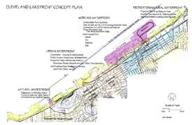
Moving the port to Burke Local planner Jim Danek has come up with an interesting idea to move the Port Authority to the east end of Burke Lakefront Airport, thus creating a multi-modal air-water-rail facility and freeing up the lakefront near downtown for other uses. Below is his detailed explanation. My concept for the lakefront tries to provide for a variety of needed and desired uses arranged in a manner to form distinct, well functioning districts that complement and support uses in adjacent non-lakefront districts. It attempts to maximize public access to the waterfront while recognizing that there are locations where other uses on the water's edge can be unique assets for the city and region. My ideas break the lakefront into four segments:
The Recreation/Natural Waterfront - West (Edgewater Park to the west bank of the Cuyahoga River) This area would focus on open space and parkland. It would build off Edgewater Park, incorporate the existing open space on Whiskey Island, and would include the port's raw material storage site in between to create an almost continuous access to the lakeshore of three miles and 270 acres. The port's facility should be relocated as part of a consolidation of port facilities to the east. Moving the facility would lessen some of the truck traffic through the Flats and the city's near west side. The most natural access to the lakefront is at the mouth of the Cuyahoga River. Most of our lakefront is not the original shoreline. Moses Cleaveland landed on the banks of the Cuyahoga River and not on the Lake Erie shoreline because there were 50-foot bluffs along most of the lakefront and the river was the easiest way to get to the land from the lake. It makes sense that the most natural way to access the lake from the land is near the same location. The eastern end of Whiskey Island has both a closeness and remoteness that create an experience that is unique in Cleveland. Sitting near the water on the picnic tables at the Sawmill Tavern you would never guess that you were in a big city, except for the tops of the taller downtown buildings which extend upward out of the scrub vegetation in the foreground. The state is looking to expand the Ohio Circle Tour into a heritage tourism corridor. This natural waterfront area could become a destination along that route. The mouth of the river is also the natural terminus of the Ohio and Erie Canal National Heritage Corridor, and it should be the terminus of the corridor's Towpath Trail. This is the location to tie the community's two main waterfronts together. After all, Cleveland is as much a river city as a lake city. Developing a connection between the west side of the Flats and open space on the lake could also help diversify the Flats as an entertainment and recreation destination. With improved access, the old Coast Guard Station at the mouth of the river could become a viable summertime venue. The Urban Waterfront The area between the Cuyahoga River and the western end of Burke Lakefront Airport is the best place to develop a lakefront that can be integrated into downtown and developed with uses that complement and support districts like the Flats, the Warehouse District, Tower City and North Coast Harbor. The Port of Cleveland, however, occupies approximately 95 acres in this area. I feel a key component of creating a lakefront that works with the rest of the city is a relocation, and hopefully an upgrading, of the Port of Cleveland. The lakefront near the east bank of the Cuyahoga River should be the primary spot for the creation of lakefront housing. In this location the housing will become part of downtown. Housing on the lakefront that is too far east of the main portion of downtown will be very difficult to orient to the downtown. It will become an island of housing that is more easily connected to the freeway system. It will also become competition for the Warehouse District and Gateway neighborhoods. Housing on the lakefront near the river will act as an extension of the Warehouse District, and its close proximity will also support restaurants, nightclubs and stores in both the Warehouse District and the Flats. Public access along the river and most of the lakefront should be designed into any new development. An exception may be adjacent to the western slips that the port now uses. These slips could be converted into marinas for adjacent housing. This would create a unique housing product which is not now available in the city. Public access along the edge of the slips would still provide visual access to this area. One of the slips could be converted to a boat launch for the public. The population of this area would also create a market for use of the RTA Waterfront Line. Lakewood's Gold Coast area (north of Lake Road) has approximately 50 units per acre. Applying that figure to 50 acres of the downtown lakefront would result in potentially 2,500 units of housing. The housing and open space along the lake would be within easy walking distance of the transit station, which has already been designed into the Waterfront Line route. A future consideration for creating a stronger connection to the Warehouse District may be to expand the W. 9th Street Bridge structure so that it acts like the Seattle Freeway Park or Lincoln Park in Cincinnati. These bridges serve as parks and create stronger connections between the uses on either side. A similar structure here would create a more pleasant connection, provide additional open space, and offer excellent views. Moving the port would also provide additional space for the expansion of venues at North Coast Harbor. Consolidating port activities toward the east end of Burke Lakefront Airport could also open space for the relocation of the Coast Guard Station to the west end of Burke. Any new construction should include continuous public access to the water. New development should also be targeted to the Waterfront Line Station on E. 9th Street to provide an additional market for the route and to serve as an activity node between North Coast Harbor and downtown. The Working Waterfront Port and transportation facilities are currently stretched out along much of the lakefront with open space and public uses interspersed between. Consolidating port facilities into one area would free up space elsewhere on the lakefront and could also upgrade multi-modal distribution opportunities compared to the current port configurations. Dike 12, a completed dredge disposal facility located at the far northeastern end of Burke Lakefront Airport, is approximately 115 to 130 acres in size (depending on what boundary one assumes) and could be used for relocating the Port of Cleveland (the Port currently occupies 95 acres near downtown and approximately 40 acres on Whiskey Island). There is also a fill site to the west that could be used for future port expansion. This area has been talked about in past for the relocation of Burke's runways to the north to allow for more development near North Coast Harbor. If the focus of new development is shifted west toward the Cuyahoga River, then the need to move those runways should be lessened. Money obtained from sale of current port property for future housing could be used to defray part of the cost for new bulkheading needed to allow Dike 12 to accommodate ships. The question of whether the Port of Cleveland really needs as much land on the lakefront as it currently occupies needs to be visited. If we were developing a new lakefront from scratch I probably would not put an airport on the lake. But we do have Burke Lakefront Airport and in a new economy where air commerce is quickly becoming its logistical backbone, I think we should first be looking to see if this potential asset is being used to its maximum capabilities, or if there are improvements that can be made so that it better functions as an economic engine. Compared to other airport locations it has a relatively small impact on residential areas; it is located on the freeway system; it is close to a major rail line; and it is adjacent to a large industrial district. The Aviation High School building (which I also thought might make a good environmental learning center/youth hostel) might be utilized for port administration offices. Burke Lakefront Airport and Port of Cleveland offices could be located in the same facility near the eastern end of Burke, which would promote a coordination of port activities. This would also free up the current Burke Terminal for other uses (i.e. the relocation of the Coast Guard, an environmental learning center, or other federal or state offices focused on the ecology of the Great Lakes or wind power technology). With current communications technology, it's possible that the tower and radar could stay in the existing Burke Terminal while offices and passenger gates are moved to the east end of the airport. The current transportation planning efforts for the Innerbelt and Shoreway provide an ideal time to consider how a reoriented Burke Lakefront Airport and a relocated Port of Cleveland could integrated into the roadway and rail systems. Moving the Port to the east provides more direct access to the freeway system and would reduce the amount of truck traffic near downtown. The transportation planning studies should also include the routing of a rail spur to the port properties. The prospects of increased business activity would be an incentive for the rail company to pay for this improvement. Transportation improvements should also include a direct connection between the port facilities and the LADCO industrial area south of the Shoreway. The close proximity of this district to multiple modes of transportation would provide a basis for the development of an e-commerce distribution center. As technology becomes an ever-increasing part of our lives and economy, energy becomes a more important resource. According to a study by the National Renewable Energy Laboratory, Lake Erie is one of four locations in the country with the potential for the development of off-shore wind turbines. Freezing of the lake could cause wear on the structures, increasing the cost of the energy produced. Dikes along the lakeshore are being filled sooner than anticipated and new sites are being sought. One option would be the creation of "islands" in the lake (one could incorporate the existing breakwall) on which windmills could be located for the creation of wind energy. Placing the turbines on a landform would negate the effects of ice on the structures. These windmills could become a symbol for a new Cleveland. The federal government should promote research the potential for wind power on Lake Erie and the possibility of creating a demonstration project. Although the lakeshore itself is occupied by transportation uses, there should still be an attractive greenway along the district's southern edge. The proposed boulevard and trail concept would make this connection. There should be pockets of green along the route and a bridge that would be required to cross a rail spur could also be developed as an overlook for trail users. The Recreation/Natural Waterfront - East The area east of Burke Lakefront Airport should continue to be a mix of recreation and open space with improvements to make trail and roadway connections easier and more attractive. The proposed relocation of the Shoreway to the south will expand the width of the lakeshore open space, which should make this a more cohesive and attractive lakeshore area. I think Dike 14 at Gordon Park should remain a natural area. The site is remote compared to other parts of the city, and keeping it natural will reinforce its character as a retreat from urban life. Other potential improvements, like a sculpture garden, should be located elsewhere in the city where the investment can have a positive impact on a city neighborhood. An educational facility near Dike 14 would, however, provide a setting that would complement the environmental learning experience. Reintroducing Doan Brook into the plans for Gordon Park near the lakefront should also be considered. Improving public access to the lakeshore on the Navy Finance Center property should also be pursued. City and state leases with marinas along the lake should also be reviewed to see if they could be changed to require public access.
EcoCity Cleveland
|
The current transportation planning efforts for the Innerbelt and Shoreway provide an ideal time to consider how a reoriented Burke Lakefront Airport and a relocated Port of Cleveland could integrated into the roadway and rail systems.
|
||||
Banyak pemain mencari slot yang memberikan peluang menang lebih besar. Dengan Slot Deposit 5k, pemain bisa menikmati permainan dengan tingkat kemenangan yang lebih tinggi dibandingkan biasanya. Ini menjadi pilihan utama bagi mereka yang ingin memaksimalkan kemenangan dengan modal kecil.
Banyak pemain berpengalaman memanfaatkan data harian untuk memilih mesin dengan slot rtp tertinggi hari ini. Ini menjadi salah satu cara untuk meningkatkan peluang menang secara signifikan. Dengan adanya RTP live, pemain bisa mendapatkan informasi real-time tentang slot mana yang lebih menguntungkan. Memilih mesin dengan slot gacor juga menjadi trik yang banyak digunakan untuk mendekati kemenangan besar.
Simbol Scatter Hitam dalam permainan slot berfungsi sebagai pemicu fitur bonus yang menguntungkan. Ketika muncul di layar, Scatter ini memberikan kesempatan untuk mendapatkan free spins atau hadiah spesial lainnya. Dengan posisi yang strategis, Mahjong Slot meningkatkan peluang pemain untuk memperoleh hadiah yang lebih besar dalam setiap permainan.
Skin eksklusif terbaru langsung jadi incaran para player sultan, detail lengkapnya ada di bd-innovations.com. Server game tadi sempat maintenance cukup lama. Untungnya sekarang sudah normal lagi dan bisa push rank.
Skin eksklusif yang lagi rame dipakai player top ternyata bisa didapat dengan cara yang cukup simpel, langkah lengkapnya ada di pedetogel. Banyak pemain baru sering bingung cara cepat naik level di awal permainan. Padahal ada beberapa tips sederhana yang bisa mempercepat progres.
Skin eksklusif terbaru ini bikin karakter kamu makin standout di arena, langsung intip tampilannya via TOGEL158. Main bareng teman bikin game lebih seru. Apalagi kalau pakai voice chat sambil bercanda.
Skin eksklusif terbaru akhirnya muncul dengan desain yang beda dari sebelumnya dan bikin karakter makin standout langsung cek situs toto. Tips farming yang efisien sekarang banyak dibagi pemain veteran di forum. Lumayan ngebantu pemain baru biar nggak salah langkah.
Skin eksklusif edisi terbatas ini cuma muncul sekali dan detail lengkapnya ada pada Situs Toto. Update patch biasanya membawa balancing karakter atau senjata. Hal ini penting supaya permainan tetap adil bagi semua pemain.
Skin eksklusif edisi terbatas ini cuma muncul sebentar dan efek animasinya beda dari biasanya, cara dapetinnya bisa kamu simak lewat toto slot. Meta terbaru bikin beberapa karakter jadi overpowered. Saatnya atur ulang strategi biar tetap kompetitif.
Banyak pemain slot online yang mencari permainan dengan RTP tinggi, dan Slot Gacor menjadi salah satu yang paling dicari. Game ini dikenal memiliki pola permainan yang mudah dipahami dan sering memberikan kemenangan besar. Dengan tampilan modern serta berbagai fitur bonus yang menarik, pengalaman bermain semakin seru. Tidak heran jika game ini selalu menjadi pilihan utama bagi para penggemar slot yang ingin mendapatkan cuan besar.
Dalam dunia hiburan digital yang terus berkembang, banyak orang memilih metode transaksi modern dan cepat, sehingga Slot Qris menjadi solusi praktis untuk menikmati permainan tanpa repot proses pembayaran.
Dalam dunia permainan online, banyak strategi yang bisa diterapkan, namun salah satu metode yang sering direkomendasikan oleh pemain berpengalaman adalah mencoba slot bet kecil untuk menguji pola permainan sebelum meningkatkan taruhan.
Saat ini, banyak pemain mencari platform terpercaya untuk bermain, dan Situs Toto hadir sebagai solusi terbaik. Dengan tampilan yang user-friendly, pemain dapat dengan mudah menelusuri berbagai fitur yang tersedia. Kemudahan dalam melakukan deposit dan withdraw juga menjadi salah satu faktor utama yang membuat banyak orang memilih platform ini.
Sebagai salah satu situs yang sangat populer, Situs Togel menawarkan berbagai pasaran dari negara-negara terkemuka. Di sini, pemain dapat menemukan pilihan pasaran seperti Hongkong, Singapore, hingga Macau, yang semuanya memiliki hasil pengundian yang akurat. Dengan tampilan yang sederhana namun efisien, Situs Togel memberikan kemudahan bagi pemain untuk bertaruh dengan nyaman.
Banyak pemain togel yang mengandalkan Data Macau sebagai referensi utama dalam menyusun strategi taruhan mereka. Data ini mencakup hasil keluaran sebelumnya yang bisa dianalisis untuk menemukan pola angka tertentu. Dengan menggunakan metode statistik, banyak pemain yang berhasil meningkatkan peluang kemenangan mereka. Selain itu, beberapa situs togel juga menawarkan layanan analisis data yang lebih mendalam. Oleh karena itu, memiliki akses ke data ini sangat penting bagi setiap pemain togel.
Ketika membahas permainan angka, tidak sedikit pemain yang menjadikan Toto macau sebagai pilihan utama karena menawarkan sensasi menegangkan sekaligus kesempatan mendapatkan hadiah besar.
Kinerja stabil dan dukungan teknologi terkini membuat slot server Thailand menjadi pilihan favorit, terutama bagi pemain yang mengutamakan kenyamanan, kecepatan, dan keadilan dalam bermain.
Setiap pemain memiliki preferensi sendiri dalam memilih platform permainan, namun di antara banyaknya nama besar, kehadiran Slot88 di dunia hiburan digital menjadi simbol konsistensi dalam memberikan layanan cepat, tampilan menarik, serta reputasi sebagai tempat bermain yang adil dan menguntungkan.
Proses registrasi menjadi lebih sederhana karena sistem permainan kini memanfaatkan Togel Online sebagai elemen pendukung utama yang mempermudah langkah awal pemain.
Skin eksklusif edisi terbatas ini cuma muncul sekali dan tampilannya bikin karakter makin sangar, intip dulu toto togel. Kalau koneksi sering drop coba main di jam sepi. Ping lebih stabil dan matchmaking biasanya lebih cepat.
Skin eksklusif yang baru rilis ini bukan cuma soal tampilan, tapi juga efek animasi yang bisa kamu lihat pada toto togel. Update patch kecil sering dianggap sepele padahal dampaknya besar. Perubahan kecil bisa bikin meta bergeser.
Skin eksklusif edisi terbatas ini cuma muncul sebentar dan efek animasinya bikin auto pamer di lobby, intip toto togel. Update kecil kadang kelihatan sepele tapi efeknya ke gameplay besar banget. Salah build dikit bisa langsung kalah di ranked.
Skin eksklusif edisi terbatas ini bikin tampilan karakter makin beda dari yang lain, detail lengkapnya bisa kamu lihat pada Bandar Togel. Banyak pemain lama balik main karena ada reward comeback menarik. Progress jadi nggak terasa ketinggalan jauh.
Skin eksklusif yang cuma muncul sekali ini lagi jadi incaran banyak player dan detailnya ada pada toto slot. Patch balance kadang bikin karakter favorit jadi makin kuat. Tapi ada juga yang harus rela ganti strategi.
Skin limited lagi comeback dan tampilannya bikin ngiler, cek detailnya pada Situs Togel. Kalau ping kamu sering naik turun, coba ganti server yang paling dekat. Main jadi lebih smooth dan nggak gampang emosi.
Skin eksklusif limited lagi balik lagi dan tampilannya makin sangar, info lengkapnya bisa kamu intip lewat situs toto. Tips buat push rank: jangan egois dan fokus objektif. Komunikasi tim itu kunci biar menang terus.
Skin limited edisi spesial udah nongol dan animasinya gokil parah, list skinnya cek Toto Togel. Kalau kamu sering kalah, coba cek ulang build dan item yang kamu pakai. Kadang masalahnya cuma salah urutan beli.
Banyak forum berbagi pengalaman menyarankan pendekatan realistis, karena meskipun Togel menawarkan sensasi menebak angka, pemahaman probabilitas dan batasan pribadi tetap menjadi fondasi penting dalam setiap keputusan.
Skin eksklusif edisi terbatas ini lagi jadi incaran para pemain karena tampilannya beda dari biasanya, lihat detailnya sabatoto. Komunitas game makin rame dengan diskusi strategi terbaru. Banyak tips berguna yang bisa kamu tiru dari sana.
Skin eksklusif terbaru akhirnya rilis juga dan tampilannya bikin karakter makin keren, lihat tampilannya di togel279. Tips leveling cepat lagi banyak dicari pemain baru. Strategi ini bisa bantu kamu naik level tanpa ribet.
Skin eksklusif terbaru ini lagi jadi incaran banyak player karena tampilannya keren banget, lihat detailnya pada Togel158. Tips leveling cepat selalu jadi incaran pemain baru. Dengan strategi yang tepat, progress bisa lebih ngebut.
Togel178 menyediakan berbagai jenis permainan yang bisa dipilih oleh para pemain, dari yang paling sederhana hingga yang lebih kompleks, semuanya bisa ditemukan dengan mudah di situs ini.
Di Togel178, kamu akan merasa nyaman bermain karena platform ini tidak hanya menawarkan berbagai jenis permainan tetapi juga menjamin transaksi yang aman dan terpercaya.
Perkembangan dunia permainan online semakin pesat dan banyak pemain mulai beralih ke Ratukura karena layanan yang tersedia mampu memberikan kenyamanan akses serta transaksi praktis tanpa proses rumit.